You are here: Home > Network List > CD - China Digital Seismograph Network Stations List
> Station ENH Enshi, Hubei Province, China > Earthquake Result Viewer
ENH Enshi, Hubei Province, China - Earthquake Result Viewer

| Earthquake location: |
Solomon Islands |
| Earthquake latitude/longitude: |
-8.6/156.6 |
| Earthquake time(UTC): |
1995/04/17 (107) 01:14:20 GMT |
| Earthquake Depth: |
36 km |
| Earthquake Magnitude: |
5.8 MB, 6.0 MS, 5.9 UNKNOWN, 6.1 MW |
| Earthquake Catalog/Contributor: |
WHDF/NEIC |
|
| Network: |
CD China Digital Seismograph Network |
| Station: |
ENH Enshi, Hubei Province, China |
| Lat/Lon: |
30.27 N/109.49 E |
| Elevation: |
487 m |
|
| Distance: |
59.5 deg |
| Az: |
312.616 deg |
| Baz: |
122.728 deg |
| Ray Param: |
0.062088966 |
| Estimated Moho Depth: |
55.25 km |
| Estimated Crust Vp/Vs: |
1.68 |
| Assumed Crust Vp: |
6.083 km/s |
| Estimated Crust Vs: |
3.621 km/s |
| Estimated Crust Poisson's Ratio: |
0.23 |
|
| Radial Match: |
87.18999 % |
| Radial Bump: |
400 |
| Transverse Match: |
88.0585 % |
| Transverse Bump: |
400 |
| SOD ConfigId: |
4480 |
| Insert Time: |
2010-02-26 21:20:05.152 +0000 |
| GWidth: |
2.5 |
| Max Bumps: |
400 |
| Tol: |
0.001 |
|
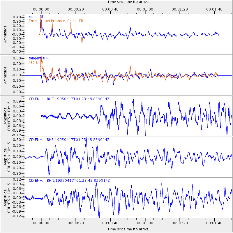
Signal To Noise
| Channel | StoN | STA | LTA |
| CD:ENH: :BHZ:19950417T01:23:48.839014Z | 8.724816 | 1.14901596E-7 | 1.3169514E-8 |
| CD:ENH: :BHN:19950417T01:23:48.839014Z | 1.6098944 | 1.5551363E-8 | 9.659865E-9 |
| CD:ENH: :BHE:19950417T01:23:48.839014Z | 2.6534505 | 2.5552023E-8 | 9.629734E-9 |
| Arrivals |
| Ps | 6.5 SECOND |
| PpPs | 23 SECOND |
| PsPs/PpSs | 30 SECOND |


