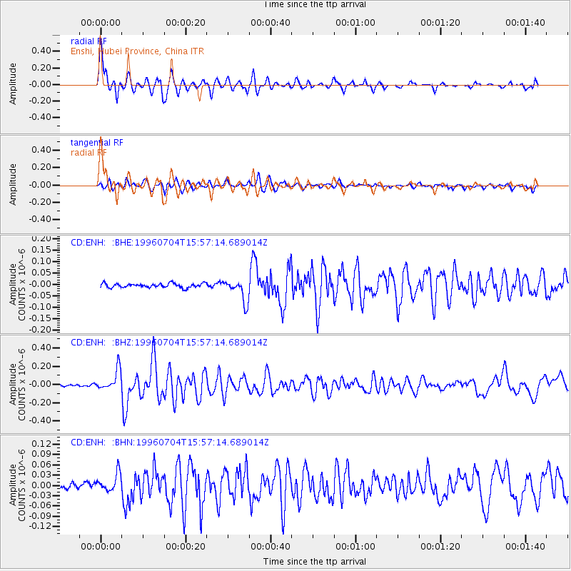
ENH Enshi, Hubei Province, China - Earthquake Result Viewer
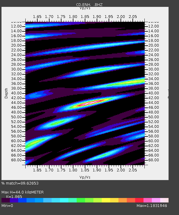
Earthquake location: W. Caroline Islands, Micronesia
Earthquake latitude/longitude: 8.5/141.6
Earthquake time(UTC): 1996/07/04 (186) 15:50:38 GMT
Earthquake Depth: 33 km
Earthquake Magnitude: 5.1 MB, 5.4 MS, 6.0 UNKNOWN, 5.9 MW
Earthquake Catalog/Contributor: WHDF/NEIC
Network: CD China Digital Seismograph Network
Station: ENH Enshi, Hubei Province, China
Lat/Lon: 30.27 N/109.49 E
Elevation: 487 m
Distance: 37.0 deg
Az: 310.23 deg
Baz: 119.196 deg
Ray Param: 0.07631524
Estimated Moho Depth: 44.0 km
Estimated Crust Vp/Vs: 1.87
Assumed Crust Vp: 6.083 km/s
Estimated Crust Vs: 3.262 km/s
Estimated Crust Poisson's Ratio: 0.30
Radial Match: 89.62653 %
Radial Bump: 400
Transverse Match: 80.637054 %
Transverse Bump: 400
SOD ConfigId: 4480
Insert Time: 2010-02-26 21:20:06.263 +0000
GWidth: 2.5
Max Bumps: 400
Tol: 0.001

Signal To Noise

ChannelStoNSTALTA
CD:ENH: :BHZ:19960704T15:57:14.689014Z12.0813821.2033789E-79.960607E-9
CD:ENH: :BHN:19960704T15:57:14.689014Z4.5492512.7260024E-85.9922E-9
CD:ENH: :BHE:19960704T15:57:14.689014Z5.60483365.102581E-89.103894E-9
Arrivals
Ps6.7 SECOND
PpPs19 SECOND
PsPs/PpSs26 SECOND