You are here: Home > Network List > CD - China Digital Seismograph Network Stations List
> Station ENH Enshi, Hubei Province, China > Earthquake Result Viewer
ENH Enshi, Hubei Province, China - Earthquake Result Viewer
| Earthquake location: |
Southeast Of Loyalty Islands |
| Earthquake latitude/longitude: |
-21.8/170.4 |
| Earthquake time(UTC): |
1995/08/17 (229) 05:35:37 GMT |
| Earthquake Depth: |
75 km |
| Earthquake Magnitude: |
5.5 MB, 6.1 UNKNOWN |
| Earthquake Catalog/Contributor: |
WHDF/NEIC |
|
| Network: |
CD China Digital Seismograph Network |
| Station: |
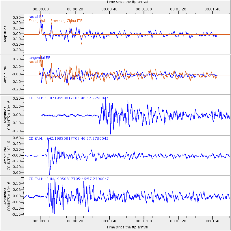
ENH Enshi, Hubei Province, China |
| Lat/Lon: |
30.27 N/109.49 E |
| Elevation: |
487 m |
|
| Distance: |
78.1 deg |
| Az: |
309.428 deg |
| Baz: |
123.939 deg |
| Ray Param: |
0.049686093 |
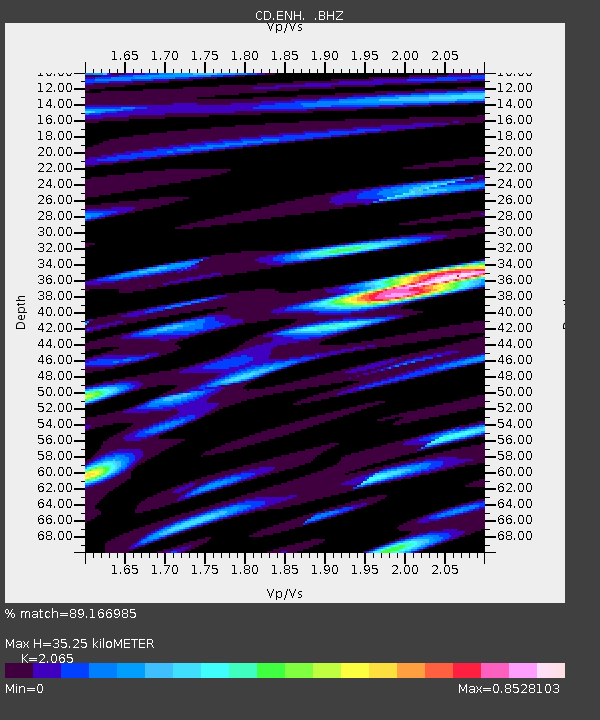
| Estimated Moho Depth: |
35.25 km |
| Estimated Crust Vp/Vs: |
2.07 |
| Assumed Crust Vp: |
6.083 km/s |
| Estimated Crust Vs: |
2.946 km/s |
| Estimated Crust Poisson's Ratio: |
0.35 |
|
| Radial Match: |
89.166985 % |
| Radial Bump: |
400 |
| Transverse Match: |
80.32408 % |
| Transverse Bump: |
400 |
| SOD ConfigId: |
4480 |
| Insert Time: |
2010-02-26 21:20:14.893 +0000 |
| GWidth: |
2.5 |
| Max Bumps: |
400 |
| Tol: |
0.001 |
|
Signal To Noise
| Channel | StoN | STA | LTA |
| CD:ENH: :BHZ:19950817T05:46:57.279004Z | 23.177038 | 1.73361E-7 | 7.47986E-9 |
| CD:ENH: :BHN:19950817T05:46:57.279004Z | 5.5927215 | 2.6845917E-8 | 4.8001527E-9 |
| CD:ENH: :BHE:19950817T05:46:57.279004Z | 4.1341767 | 2.8560365E-8 | 6.9083566E-9 |
| Arrivals |
| Ps | 6.3 SECOND |
| PpPs | 17 SECOND |
| PsPs/PpSs | 24 SECOND |


