You are here: Home > Network List > CD - China Digital Seismograph Network Stations List
> Station ENH Enshi, Hubei Province, China > Earthquake Result Viewer
ENH Enshi, Hubei Province, China - Earthquake Result Viewer
| Earthquake location: |
Solomon Islands |
| Earthquake latitude/longitude: |
-6.1/154.4 |
| Earthquake time(UTC): |
1995/08/17 (229) 18:09:59 GMT |
| Earthquake Depth: |
33 km |
| Earthquake Magnitude: |
5.6 MS, 5.2 MB, 5.6 UNKNOWN, 5.6 MW |
| Earthquake Catalog/Contributor: |
WHDF/NEIC |
|
| Network: |
CD China Digital Seismograph Network |
| Station: |
ENH Enshi, Hubei Province, China |
| Lat/Lon: |
30.27 N/109.49 E |
| Elevation: |
487 m |
|
| Distance: |
56.2 deg |
| Az: |
312.711 deg |
| Baz: |
122.375 deg |
| Ray Param: |
0.064233616 |
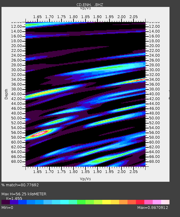
| Estimated Moho Depth: |
56.25 km |
| Estimated Crust Vp/Vs: |
1.65 |
| Assumed Crust Vp: |
6.083 km/s |
| Estimated Crust Vs: |
3.675 km/s |
| Estimated Crust Poisson's Ratio: |
0.21 |
|
| Radial Match: |
80.77692 % |
| Radial Bump: |
400 |
| Transverse Match: |
83.97317 % |
| Transverse Bump: |
400 |
| SOD ConfigId: |
4480 |
| Insert Time: |
2010-02-26 21:20:15.957 +0000 |
| GWidth: |
2.5 |
| Max Bumps: |
400 |
| Tol: |
0.001 |
|
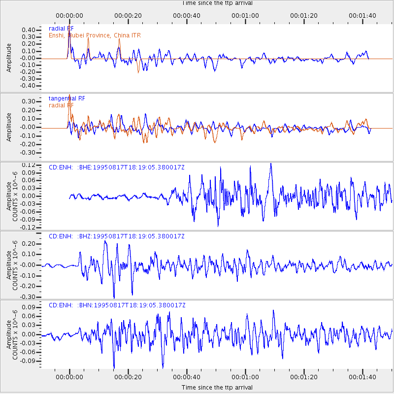
Signal To Noise
| Channel | StoN | STA | LTA |
| CD:ENH: :BHZ:19950817T18:19:05.380017Z | 6.906161 | 4.7023903E-8 | 6.8089787E-9 |
| CD:ENH: :BHN:19950817T18:19:05.380017Z | 1.9868977 | 9.627096E-9 | 4.84529E-9 |
| CD:ENH: :BHE:19950817T18:19:05.380017Z | 1.9021498 | 1.1066555E-8 | 5.8179195E-9 |
| Arrivals |
| Ps | 6.4 SECOND |
| PpPs | 23 SECOND |
| PsPs/PpSs | 30 SECOND |


