You are here: Home > Network List > TA - USArray Transportable Network (new EarthScope stations) Stations List
> Station X33A Lawton, OK, USA > Earthquake Result Viewer
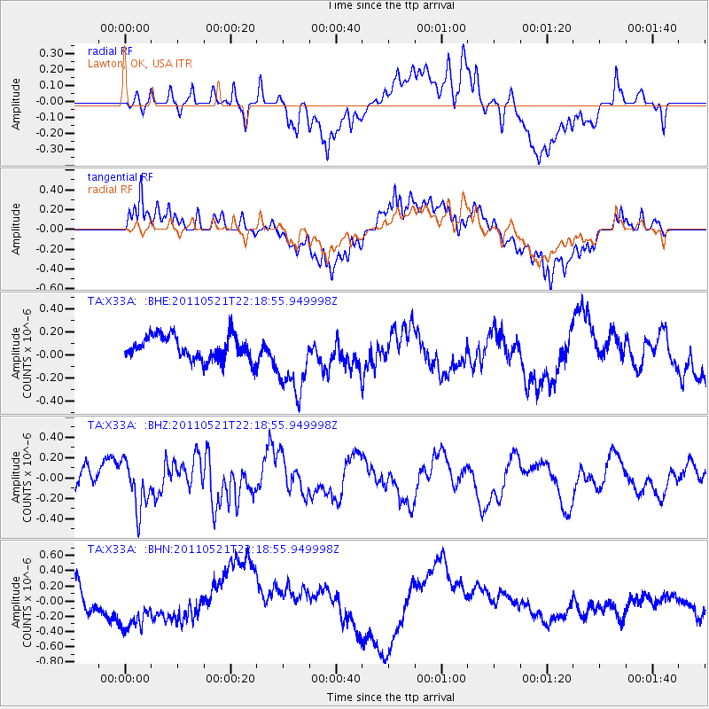
X33A Lawton, OK, USA - Earthquake Result Viewer
*The percent match for this event was below the threshold and hence no stack was calculated.
| Earthquake location: |
Near East Coast Of Honshu, Japan |
| Earthquake latitude/longitude: |
35.6/140.5 |
| Earthquake time(UTC): |
2011/05/21 (141) 22:06:26 GMT |
| Earthquake Depth: |
37 km |
| Earthquake Magnitude: |
5.5 MB, 5.0 MS, 5.5 MW, 5.6 MW |
| Earthquake Catalog/Contributor: |
WHDF/NEIC |
|
| Network: |
TA USArray Transportable Network (new EarthScope stations) |
| Station: |
X33A Lawton, OK, USA |
| Lat/Lon: |
34.54 N/98.50 W |
| Elevation: |
346 m |
|
| Distance: |
91.1 deg |
| Az: |
45.045 deg |
| Baz: |
315.681 deg |
| Ray Param: |
$rayparam |
*The percent match for this event was below the threshold and hence was not used in the summary stack. |
|
| Radial Match: |
45.83076 % |
| Radial Bump: |
400 |
| Transverse Match: |
52.04544 % |
| Transverse Bump: |
400 |
| SOD ConfigId: |
393008 |
| Insert Time: |
2011-10-28 08:25:08.824 +0000 |
| GWidth: |
2.5 |
| Max Bumps: |
400 |
| Tol: |
0.001 |
|
Signal To Noise
| Channel | StoN | STA | LTA |
| TA:X33A: :BHZ:20110521T22:18:55.949998Z | 1.3796679 | 2.2837989E-7 | 1.655325E-7 |
| TA:X33A: :BHN:20110521T22:18:55.949998Z | 1.8347741 | 3.1911662E-7 | 1.7392692E-7 |
| TA:X33A: :BHE:20110521T22:18:55.949998Z | 2.9208524 | 3.0633737E-7 | 1.0487944E-7 |
| Arrivals |
| Ps | |
| PpPs | |
| PsPs/PpSs | |


