You are here: Home > Network List > TA - USArray Transportable Network (new EarthScope stations) Stations List
> Station R36A Gordon, Harris, KS, USA > Earthquake Result Viewer
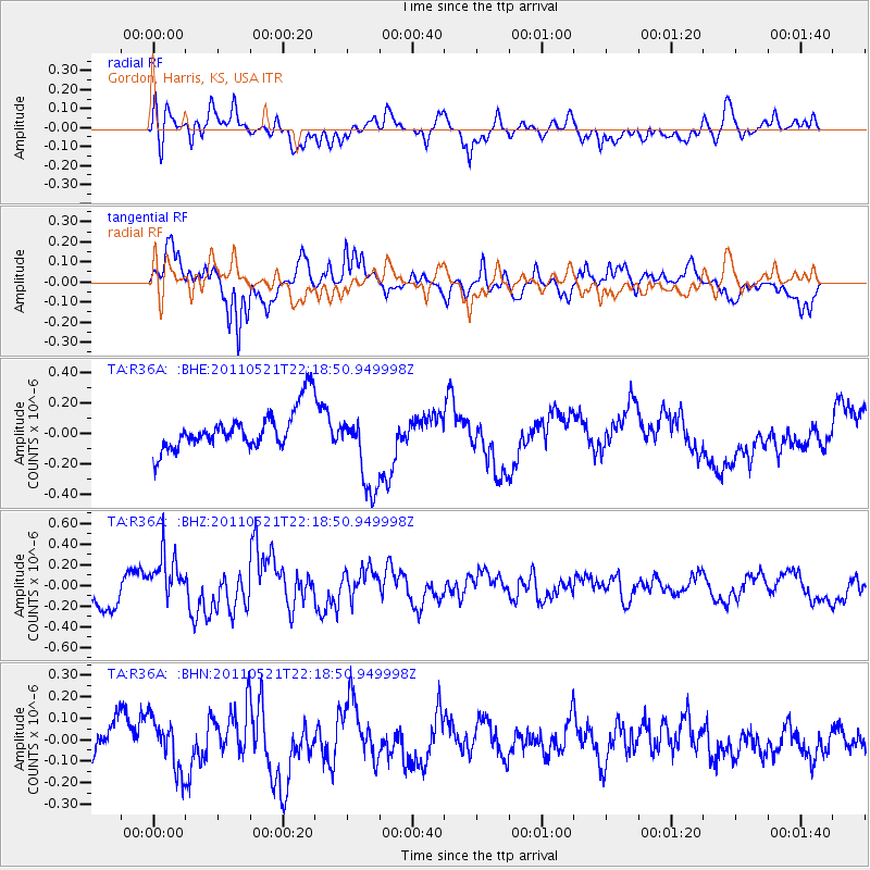
R36A Gordon, Harris, KS, USA - Earthquake Result Viewer
*The percent match for this event was below the threshold and hence no stack was calculated.
| Earthquake location: |
Near East Coast Of Honshu, Japan |
| Earthquake latitude/longitude: |
35.6/140.5 |
| Earthquake time(UTC): |
2011/05/21 (141) 22:06:26 GMT |
| Earthquake Depth: |
37 km |
| Earthquake Magnitude: |
5.5 MB, 5.0 MS, 5.5 MW, 5.6 MW |
| Earthquake Catalog/Contributor: |
WHDF/NEIC |
|
| Network: |
TA USArray Transportable Network (new EarthScope stations) |
| Station: |
R36A Gordon, Harris, KS, USA |
| Lat/Lon: |
38.32 N/95.50 W |
| Elevation: |
354 m |
|
| Distance: |
90.0 deg |
| Az: |
40.696 deg |
| Baz: |
317.498 deg |
| Ray Param: |
$rayparam |
*The percent match for this event was below the threshold and hence was not used in the summary stack. |
|
| Radial Match: |
42.02503 % |
| Radial Bump: |
400 |
| Transverse Match: |
71.31296 % |
| Transverse Bump: |
400 |
| SOD ConfigId: |
393008 |
| Insert Time: |
2011-10-28 08:26:48.500 +0000 |
| GWidth: |
2.5 |
| Max Bumps: |
400 |
| Tol: |
0.001 |
|
Signal To Noise
| Channel | StoN | STA | LTA |
| TA:R36A: :BHZ:20110521T22:18:50.949998Z | 1.86849 | 2.400766E-7 | 1.2848696E-7 |
| TA:R36A: :BHN:20110521T22:18:50.949998Z | 1.3689975 | 1.187754E-7 | 8.676086E-8 |
| TA:R36A: :BHE:20110521T22:18:50.949998Z | 2.0825942 | 2.7379227E-7 | 1.3146695E-7 |
| Arrivals |
| Ps | |
| PpPs | |
| PsPs/PpSs | |


