You are here: Home > Network List > CD - China Digital Seismograph Network Stations List
> Station ENH Enshi, Hubei Province, China > Earthquake Result Viewer
ENH Enshi, Hubei Province, China - Earthquake Result Viewer
| Earthquake location: |
Solomon Islands |
| Earthquake latitude/longitude: |
-7.2/155.7 |
| Earthquake time(UTC): |
1996/09/07 (251) 09:06:00 GMT |
| Earthquake Depth: |
10 km |
| Earthquake Magnitude: |
5.6 MS, 5.4 MB, 5.8 UNKNOWN, 5.7 MW |
| Earthquake Catalog/Contributor: |
WHDF/NEIC |
|
| Network: |
CD China Digital Seismograph Network |
| Station: |
ENH Enshi, Hubei Province, China |
| Lat/Lon: |
30.27 N/109.49 E |
| Elevation: |
487 m |
|
| Distance: |
57.9 deg |
| Az: |
312.499 deg |
| Baz: |
122.258 deg |
| Ray Param: |
0.063222 |
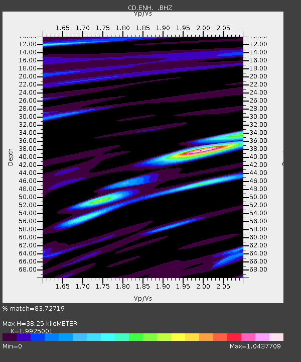
| Estimated Moho Depth: |
38.25 km |
| Estimated Crust Vp/Vs: |
1.99 |
| Assumed Crust Vp: |
6.083 km/s |
| Estimated Crust Vs: |
3.053 km/s |
| Estimated Crust Poisson's Ratio: |
0.33 |
|
| Radial Match: |
83.72719 % |
| Radial Bump: |
400 |
| Transverse Match: |
71.56733 % |
| Transverse Bump: |
400 |
| SOD ConfigId: |
4480 |
| Insert Time: |
2010-02-26 21:20:18.005 +0000 |
| GWidth: |
2.5 |
| Max Bumps: |
400 |
| Tol: |
0.001 |
|
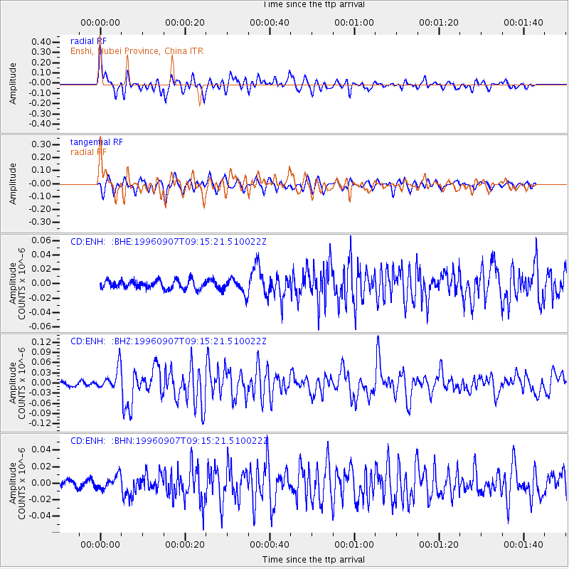
Signal To Noise
| Channel | StoN | STA | LTA |
| CD:ENH: :BHZ:19960907T09:15:21.510022Z | 4.2085376 | 3.4801346E-8 | 8.269225E-9 |
| CD:ENH: :BHN:19960907T09:15:21.510022Z | 1.1107539 | 8.5757055E-9 | 7.720617E-9 |
| CD:ENH: :BHE:19960907T09:15:21.510022Z | 1.773333 | 1.028893E-8 | 5.8020295E-9 |
| Arrivals |
| Ps | 6.5 SECOND |
| PpPs | 18 SECOND |
| PsPs/PpSs | 25 SECOND |


