You are here: Home > Network List > UW - Pacific Northwest Regional Seismic Network Stations List
> Station UMAT Pilot Rock, OR, USA > Earthquake Result Viewer
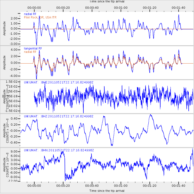
UMAT Pilot Rock, OR, USA - Earthquake Result Viewer
*The percent match for this event was below the threshold and hence no stack was calculated.
| Earthquake location: |
Near East Coast Of Honshu, Japan |
| Earthquake latitude/longitude: |
35.6/140.5 |
| Earthquake time(UTC): |
2011/05/21 (141) 22:06:26 GMT |
| Earthquake Depth: |
37 km |
| Earthquake Magnitude: |
5.5 MB, 5.0 MS, 5.5 MW, 5.6 MW |
| Earthquake Catalog/Contributor: |
WHDF/NEIC |
|
| Network: |
UW Pacific Northwest Regional Seismic Network |
| Station: |
UMAT Pilot Rock, OR, USA |
| Lat/Lon: |
45.29 N/118.96 W |
| Elevation: |
1318 m |
|
| Distance: |
72.2 deg |
| Az: |
46.78 deg |
| Baz: |
302.719 deg |
| Ray Param: |
$rayparam |
*The percent match for this event was below the threshold and hence was not used in the summary stack. |
|
| Radial Match: |
35.733284 % |
| Radial Bump: |
381 |
| Transverse Match: |
35.77092 % |
| Transverse Bump: |
400 |
| SOD ConfigId: |
393008 |
| Insert Time: |
2011-10-28 08:33:20.487 +0000 |
| GWidth: |
2.5 |
| Max Bumps: |
400 |
| Tol: |
0.001 |
|
Signal To Noise
| Channel | StoN | STA | LTA |
| UW:UMAT: :BHZ:20110521T22:17:16.824998Z | 2.5362527 | 2.9799259E-7 | 1.17493244E-7 |
| UW:UMAT: :BHN:20110521T22:17:16.824998Z | 1.2095022 | 3.3085794E-6 | 2.7354884E-6 |
| UW:UMAT: :BHE:20110521T22:17:16.824998Z | 1.0658807 | 5.1791833E-9 | 4.8590647E-9 |
| Arrivals |
| Ps | |
| PpPs | |
| PsPs/PpSs | |


