You are here: Home > Network List > IU - Global Seismograph Network (GSN - IRIS/USGS) Stations List
> Station JOHN Johnston Island, USA > Earthquake Result Viewer
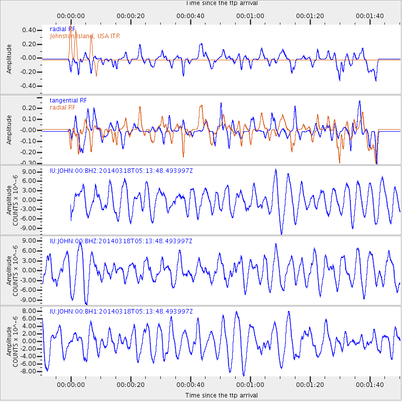
JOHN Johnston Island, USA - Earthquake Result Viewer
*The percent match for this event was below the threshold and hence no stack was calculated.
| Earthquake location: |
New Britain Region, P.N.G. |
| Earthquake latitude/longitude: |
-5.4/153.0 |
| Earthquake time(UTC): |
2014/03/18 (077) 05:06:22 GMT |
| Earthquake Depth: |
37 km |
| Earthquake Magnitude: |
5.2 MW |
| Earthquake Catalog/Contributor: |
ISC/ISC |
|
| Network: |
IU Global Seismograph Network (GSN - IRIS/USGS) |
| Station: |
JOHN Johnston Island, USA |
| Lat/Lon: |
16.73 N/169.53 W |
| Elevation: |
2.0 m |
|
| Distance: |
43.1 deg |
| Az: |
58.563 deg |
| Baz: |
242.435 deg |
| Ray Param: |
$rayparam |
*The percent match for this event was below the threshold and hence was not used in the summary stack. |
|
| Radial Match: |
47.51347 % |
| Radial Bump: |
400 |
| Transverse Match: |
42.376205 % |
| Transverse Bump: |
400 |
| SOD ConfigId: |
3390531 |
| Insert Time: |
2019-04-10 17:54:21.576 +0000 |
| GWidth: |
2.5 |
| Max Bumps: |
400 |
| Tol: |
0.001 |
|
Signal To Noise
| Channel | StoN | STA | LTA |
| IU:JOHN:00:BHZ:20140318T05:13:48.493997Z | 2.9755635 | 6.3290463E-6 | 2.1270075E-6 |
| IU:JOHN:00:BH1:20140318T05:13:48.493997Z | 0.44441894 | 1.9867782E-6 | 4.4705075E-6 |
| IU:JOHN:00:BH2:20140318T05:13:48.493997Z | 0.6727935 | 2.3519406E-6 | 3.4957836E-6 |
| Arrivals |
| Ps | |
| PpPs | |
| PsPs/PpSs | |


