You are here: Home > Network List > CD - China Digital Seismograph Network Stations List
> Station ENH Enshi, Hubei Province, China > Earthquake Result Viewer
ENH Enshi, Hubei Province, China - Earthquake Result Viewer
| Earthquake location: |
Kyrgyzstan |
| Earthquake latitude/longitude: |
42.1/73.6 |
| Earthquake time(UTC): |
1992/08/19 (232) 02:04:36 GMT |
| Earthquake Depth: |
22 km |
| Earthquake Magnitude: |
6.8 MB, 7.4 MS |
| Earthquake Catalog/Contributor: |
WHDF/NEIC |
|
| Network: |
CD China Digital Seismograph Network |
| Station: |
ENH Enshi, Hubei Province, China |
| Lat/Lon: |
30.27 N/109.49 E |
| Elevation: |
487 m |
|
| Distance: |
31.1 deg |
| Az: |
100.533 deg |
| Baz: |
302.225 deg |
| Ray Param: |
0.07914658 |
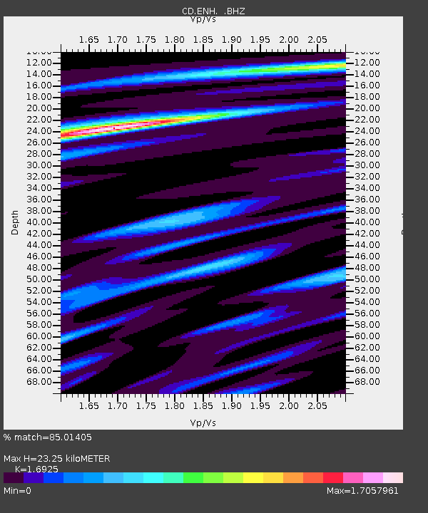
| Estimated Moho Depth: |
23.25 km |
| Estimated Crust Vp/Vs: |
1.69 |
| Assumed Crust Vp: |
6.083 km/s |
| Estimated Crust Vs: |
3.594 km/s |
| Estimated Crust Poisson's Ratio: |
0.23 |
|
| Radial Match: |
85.01405 % |
| Radial Bump: |
400 |
| Transverse Match: |
68.24749 % |
| Transverse Bump: |
400 |
| SOD ConfigId: |
4480 |
| Insert Time: |
2010-02-26 21:20:23.534 +0000 |
| GWidth: |
2.5 |
| Max Bumps: |
400 |
| Tol: |
0.001 |
|
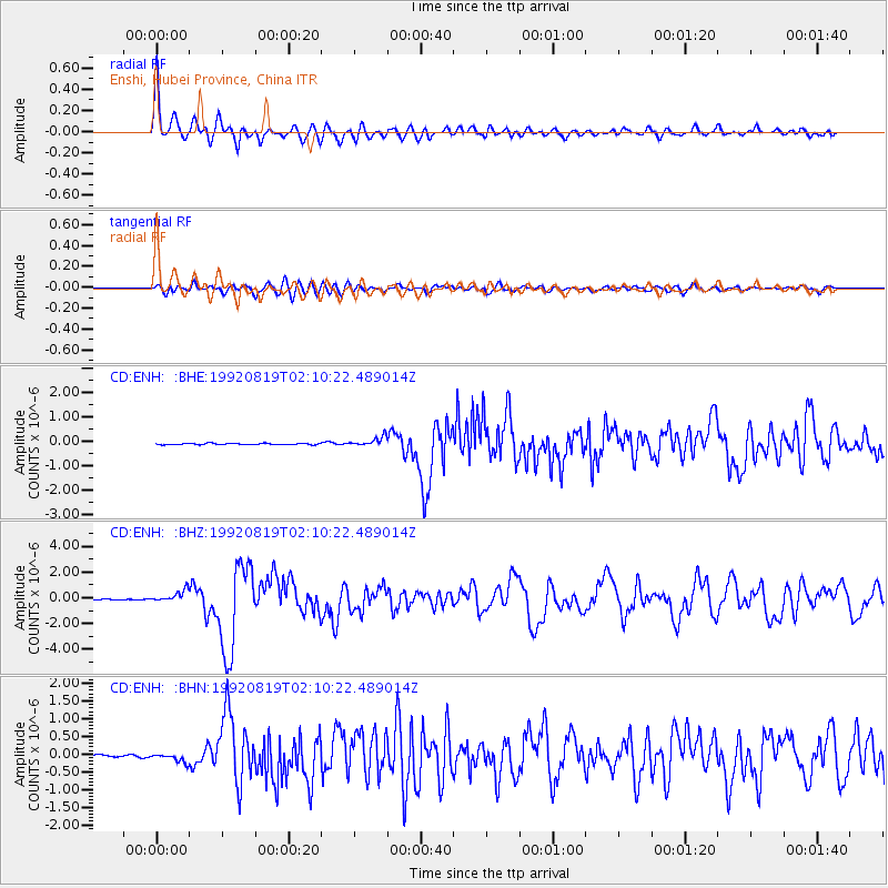
Signal To Noise
| Channel | StoN | STA | LTA |
| CD:ENH: :BHZ:19920819T02:10:22.489014Z | 9.662402 | 4.5784378E-7 | 4.7384052E-8 |
| CD:ENH: :BHN:19920819T02:10:22.489014Z | 3.210513 | 1.2267925E-7 | 3.8211727E-8 |
| CD:ENH: :BHE:19920819T02:10:22.489014Z | 6.946108 | 1.8743427E-7 | 2.6984072E-8 |
| Arrivals |
| Ps | 2.9 SECOND |
| PpPs | 9.6 SECOND |
| PsPs/PpSs | 12 SECOND |


