You are here: Home > Network List > UW - Pacific Northwest Regional Seismic Network Stations List
> Station PASS Maple Falls, WA, USA > Earthquake Result Viewer
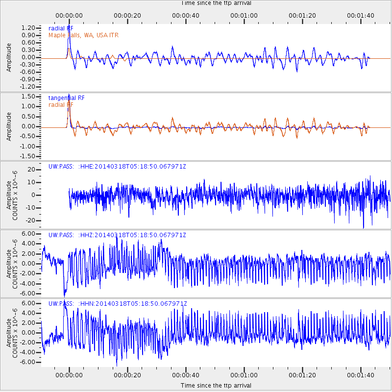
PASS Maple Falls, WA, USA - Earthquake Result Viewer
*The percent match for this event was below the threshold and hence no stack was calculated.
| Earthquake location: |
New Britain Region, P.N.G. |
| Earthquake latitude/longitude: |
-5.4/153.0 |
| Earthquake time(UTC): |
2014/03/18 (077) 05:06:22 GMT |
| Earthquake Depth: |
37 km |
| Earthquake Magnitude: |
5.2 MW |
| Earthquake Catalog/Contributor: |
ISC/ISC |
|
| Network: |
UW Pacific Northwest Regional Seismic Network |
| Station: |
PASS Maple Falls, WA, USA |
| Lat/Lon: |
49.00 N/122.09 W |
| Elevation: |
174 m |
|
| Distance: |
90.7 deg |
| Az: |
41.001 deg |
| Baz: |
262.635 deg |
| Ray Param: |
$rayparam |
*The percent match for this event was below the threshold and hence was not used in the summary stack. |
|
| Radial Match: |
73.819405 % |
| Radial Bump: |
400 |
| Transverse Match: |
98.14213 % |
| Transverse Bump: |
222 |
| SOD ConfigId: |
3390531 |
| Insert Time: |
2019-04-10 17:55:55.087 +0000 |
| GWidth: |
2.5 |
| Max Bumps: |
400 |
| Tol: |
0.001 |
|
Signal To Noise
| Channel | StoN | STA | LTA |
| UW:PASS: :HHZ:20140318T05:18:50.067971Z | 1.7807355 | 2.8797765E-6 | 1.6171838E-6 |
| UW:PASS: :HHN:20140318T05:18:50.067971Z | 1.7692472 | 3.0400574E-6 | 1.7182773E-6 |
| UW:PASS: :HHE:20140318T05:18:50.067971Z | 0.9806955 | 4.501963E-6 | 4.5905817E-6 |
| Arrivals |
| Ps | |
| PpPs | |
| PsPs/PpSs | |


