You are here: Home > Network List > CD - China Digital Seismograph Network Stations List
> Station ENH Enshi, Hubei Province, China > Earthquake Result Viewer
ENH Enshi, Hubei Province, China - Earthquake Result Viewer
| Earthquake location: |
Vanuatu Islands |
| Earthquake latitude/longitude: |
-14.2/167.5 |
| Earthquake time(UTC): |
1992/11/04 (309) 18:13:17 GMT |
| Earthquake Depth: |
33 km |
| Earthquake Magnitude: |
6.0 MB, 6.2 MS |
| Earthquake Catalog/Contributor: |
WHDF/NEIC |
|
| Network: |
CD China Digital Seismograph Network |
| Station: |
ENH Enshi, Hubei Province, China |
| Lat/Lon: |
30.27 N/109.49 E |
| Elevation: |
487 m |
|
| Distance: |
71.2 deg |
| Az: |
309.178 deg |
| Baz: |
119.636 deg |
| Ray Param: |
0.054453287 |
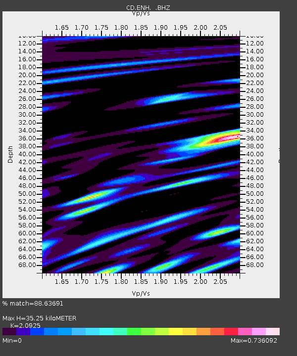
| Estimated Moho Depth: |
35.25 km |
| Estimated Crust Vp/Vs: |
2.09 |
| Assumed Crust Vp: |
6.083 km/s |
| Estimated Crust Vs: |
2.907 km/s |
| Estimated Crust Poisson's Ratio: |
0.35 |
|
| Radial Match: |
88.63691 % |
| Radial Bump: |
400 |
| Transverse Match: |
82.398834 % |
| Transverse Bump: |
400 |
| SOD ConfigId: |
4480 |
| Insert Time: |
2010-02-26 21:20:25.074 +0000 |
| GWidth: |
2.5 |
| Max Bumps: |
400 |
| Tol: |
0.001 |
|
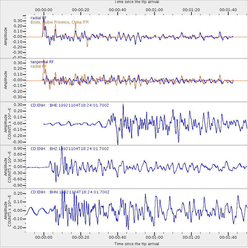
Signal To Noise
| Channel | StoN | STA | LTA |
| CD:ENH: :BHZ:19921104T18:24:01.700Z | 3.727242 | 1.1813992E-7 | 3.1696338E-8 |
| CD:ENH: :BHN:19921104T18:24:01.700Z | 1.0983468 | 2.0626224E-8 | 1.8779335E-8 |
| CD:ENH: :BHE:19921104T18:24:01.700Z | 2.6882186 | 3.8960646E-8 | 1.4493111E-8 |
| Arrivals |
| Ps | 6.5 SECOND |
| PpPs | 17 SECOND |
| PsPs/PpSs | 24 SECOND |


