You are here: Home > Network List > BK - Berkeley Digital Seismograph Network Stations List
> Station HUMO Hull Mountain, OR > Earthquake Result Viewer
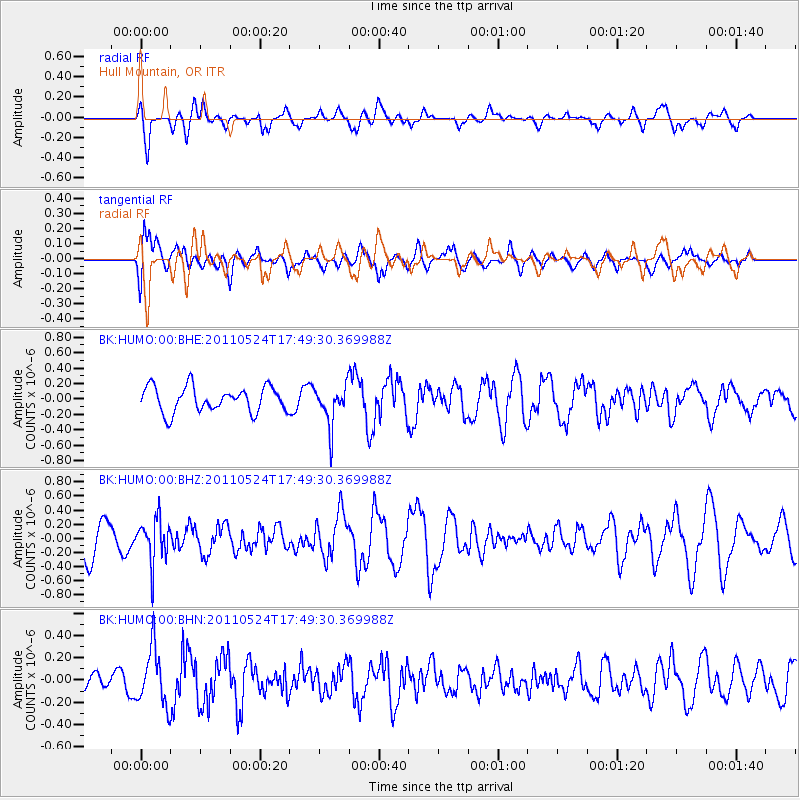
HUMO Hull Mountain, OR - Earthquake Result Viewer
*The percent match for this event was below the threshold and hence no stack was calculated.
| Earthquake location: |
Andreanof Islands, Aleutian Is. |
| Earthquake latitude/longitude: |
52.6/-173.3 |
| Earthquake time(UTC): |
2011/05/24 (144) 17:43:24 GMT |
| Earthquake Depth: |
138 km |
| Earthquake Magnitude: |
5.6 MB, 5.5 MW, 5.5 MW |
| Earthquake Catalog/Contributor: |
WHDF/NEIC |
|
| Network: |
BK Berkeley Digital Seismograph Network |
| Station: |
HUMO Hull Mountain, OR |
| Lat/Lon: |
42.61 N/122.96 W |
| Elevation: |
555 m |
|
| Distance: |
34.7 deg |
| Az: |
86.197 deg |
| Baz: |
304.468 deg |
| Ray Param: |
$rayparam |
*The percent match for this event was below the threshold and hence was not used in the summary stack. |
|
| Radial Match: |
71.46428 % |
| Radial Bump: |
400 |
| Transverse Match: |
66.209175 % |
| Transverse Bump: |
400 |
| SOD ConfigId: |
393008 |
| Insert Time: |
2011-10-28 08:55:15.201 +0000 |
| GWidth: |
2.5 |
| Max Bumps: |
400 |
| Tol: |
0.001 |
|
Signal To Noise
| Channel | StoN | STA | LTA |
| BK:HUMO:00:BHZ:20110524T17:49:30.369988Z | 1.3033133 | 3.023922E-7 | 2.3201805E-7 |
| BK:HUMO:00:BHN:20110524T17:49:30.369988Z | 1.9017423 | 2.5300946E-7 | 1.3304088E-7 |
| BK:HUMO:00:BHE:20110524T17:49:30.369988Z | 1.5958118 | 2.5952247E-7 | 1.6262723E-7 |
| Arrivals |
| Ps | |
| PpPs | |
| PsPs/PpSs | |


