You are here: Home > Network List > CI - Caltech Regional Seismic Network Stations List
> Station FUR Furnace Creek, CA, USA > Earthquake Result Viewer
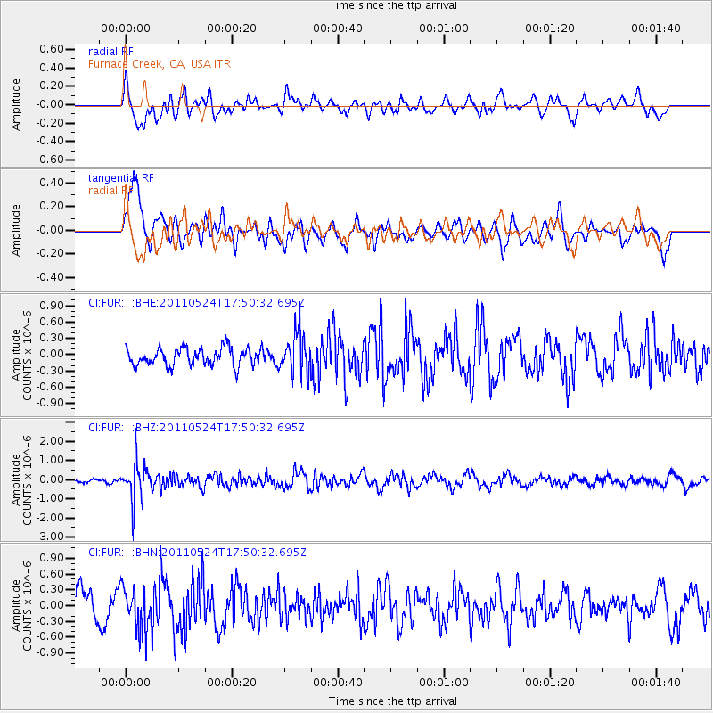
FUR Furnace Creek, CA, USA - Earthquake Result Viewer
*The percent match for this event was below the threshold and hence no stack was calculated.
| Earthquake location: |
Andreanof Islands, Aleutian Is. |
| Earthquake latitude/longitude: |
52.6/-173.3 |
| Earthquake time(UTC): |
2011/05/24 (144) 17:43:24 GMT |
| Earthquake Depth: |
138 km |
| Earthquake Magnitude: |
5.6 MB, 5.5 MW, 5.5 MW |
| Earthquake Catalog/Contributor: |
WHDF/NEIC |
|
| Network: |
CI Caltech Regional Seismic Network |
| Station: |
FUR Furnace Creek, CA, USA |
| Lat/Lon: |
36.47 N/116.86 W |
| Elevation: |
-37.0 m |
|
| Distance: |
42.2 deg |
| Az: |
89.365 deg |
| Baz: |
310.827 deg |
| Ray Param: |
$rayparam |
*The percent match for this event was below the threshold and hence was not used in the summary stack. |
|
| Radial Match: |
43.55715 % |
| Radial Bump: |
400 |
| Transverse Match: |
71.12658 % |
| Transverse Bump: |
400 |
| SOD ConfigId: |
393008 |
| Insert Time: |
2011-10-28 08:57:15.174 +0000 |
| GWidth: |
2.5 |
| Max Bumps: |
400 |
| Tol: |
0.001 |
|
Signal To Noise
| Channel | StoN | STA | LTA |
| CI:FUR: :BHZ:20110524T17:50:32.695Z | 6.6208787 | 9.828378E-7 | 1.4844524E-7 |
| CI:FUR: :BHN:20110524T17:50:32.695Z | 1.4408505 | 3.9365307E-7 | 2.7320883E-7 |
| CI:FUR: :BHE:20110524T17:50:32.695Z | 2.2920942 | 3.685486E-7 | 1.6079122E-7 |
| Arrivals |
| Ps | |
| PpPs | |
| PsPs/PpSs | |


