You are here: Home > Network List > CI - Caltech Regional Seismic Network Stations List
> Station MPM Manuel Prospect Mine, California, USA > Earthquake Result Viewer
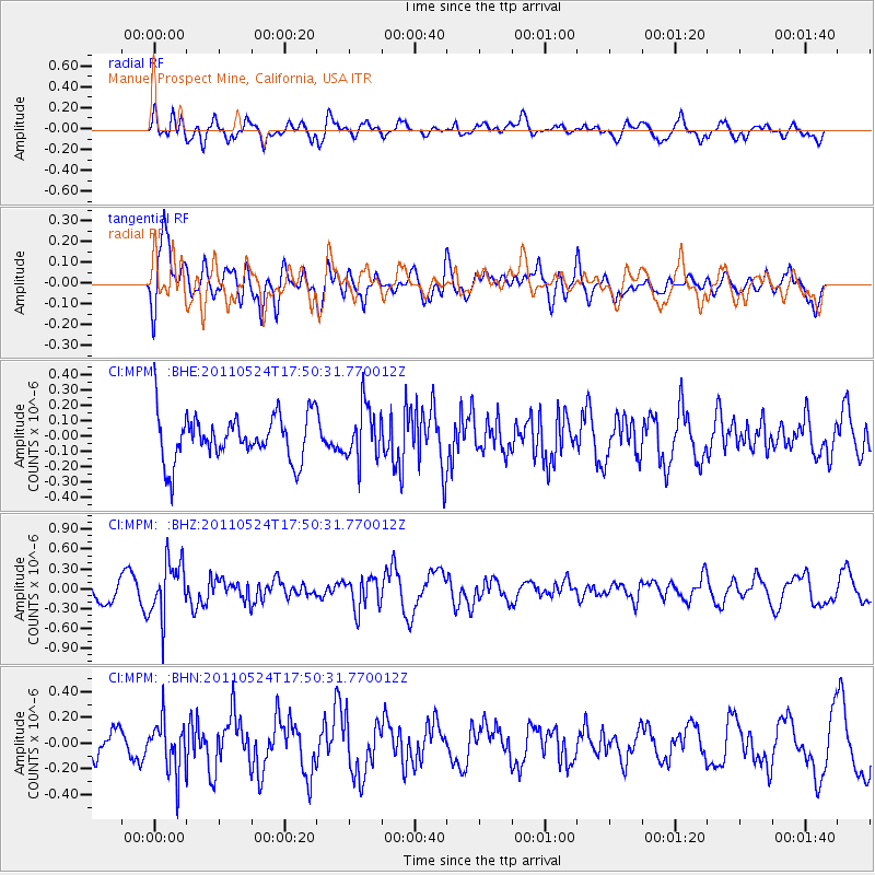
MPM Manuel Prospect Mine, California, USA - Earthquake Result Viewer
*The percent match for this event was below the threshold and hence no stack was calculated.
| Earthquake location: |
Andreanof Islands, Aleutian Is. |
| Earthquake latitude/longitude: |
52.6/-173.3 |
| Earthquake time(UTC): |
2011/05/24 (144) 17:43:24 GMT |
| Earthquake Depth: |
138 km |
| Earthquake Magnitude: |
5.6 MB, 5.5 MW, 5.5 MW |
| Earthquake Catalog/Contributor: |
WHDF/NEIC |
|
| Network: |
CI Caltech Regional Seismic Network |
| Station: |
MPM Manuel Prospect Mine, California, USA |
| Lat/Lon: |
36.06 N/117.49 W |
| Elevation: |
185 m |
|
| Distance: |
42.1 deg |
| Az: |
90.319 deg |
| Baz: |
311.166 deg |
| Ray Param: |
$rayparam |
*The percent match for this event was below the threshold and hence was not used in the summary stack. |
|
| Radial Match: |
63.976337 % |
| Radial Bump: |
400 |
| Transverse Match: |
67.06802 % |
| Transverse Bump: |
400 |
| SOD ConfigId: |
393008 |
| Insert Time: |
2011-10-28 08:57:32.415 +0000 |
| GWidth: |
2.5 |
| Max Bumps: |
400 |
| Tol: |
0.001 |
|
Signal To Noise
| Channel | StoN | STA | LTA |
| CI:MPM: :BHZ:20110524T17:50:31.770012Z | 2.9014146 | 4.1638975E-7 | 1.4351266E-7 |
| CI:MPM: :BHN:20110524T17:50:31.770012Z | 1.0195323 | 2.0182358E-7 | 1.9795702E-7 |
| CI:MPM: :BHE:20110524T17:50:31.770012Z | 1.16058 | 1.7370066E-7 | 1.4966712E-7 |
| Arrivals |
| Ps | |
| PpPs | |
| PsPs/PpSs | |


