You are here: Home > Network List > CI - Caltech Regional Seismic Network Stations List
> Station SLA SLA, Trona, CA, USA > Earthquake Result Viewer
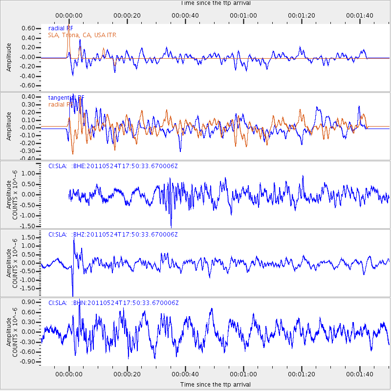
SLA SLA, Trona, CA, USA - Earthquake Result Viewer
*The percent match for this event was below the threshold and hence no stack was calculated.
| Earthquake location: |
Andreanof Islands, Aleutian Is. |
| Earthquake latitude/longitude: |
52.6/-173.3 |
| Earthquake time(UTC): |
2011/05/24 (144) 17:43:24 GMT |
| Earthquake Depth: |
138 km |
| Earthquake Magnitude: |
5.6 MB, 5.5 MW, 5.5 MW |
| Earthquake Catalog/Contributor: |
WHDF/NEIC |
|
| Network: |
CI Caltech Regional Seismic Network |
| Station: |
SLA SLA, Trona, CA, USA |
| Lat/Lon: |
35.89 N/117.28 W |
| Elevation: |
1174 m |
|
| Distance: |
42.3 deg |
| Az: |
90.342 deg |
| Baz: |
311.303 deg |
| Ray Param: |
$rayparam |
*The percent match for this event was below the threshold and hence was not used in the summary stack. |
|
| Radial Match: |
64.62036 % |
| Radial Bump: |
400 |
| Transverse Match: |
60.17188 % |
| Transverse Bump: |
400 |
| SOD ConfigId: |
393008 |
| Insert Time: |
2011-10-28 08:57:54.291 +0000 |
| GWidth: |
2.5 |
| Max Bumps: |
400 |
| Tol: |
0.001 |
|
Signal To Noise
| Channel | StoN | STA | LTA |
| CI:SLA: :BHZ:20110524T17:50:33.670006Z | 4.7831416 | 6.225173E-7 | 1.3014821E-7 |
| CI:SLA: :BHN:20110524T17:50:33.670006Z | 1.7084893 | 3.1733478E-7 | 1.8573998E-7 |
| CI:SLA: :BHE:20110524T17:50:33.670006Z | 1.7411036 | 3.7977944E-7 | 2.1812568E-7 |
| Arrivals |
| Ps | |
| PpPs | |
| PsPs/PpSs | |


