You are here: Home > Network List > CI - Caltech Regional Seismic Network Stations List
> Station LGU LGU, Camarillo, CA, USA > Earthquake Result Viewer
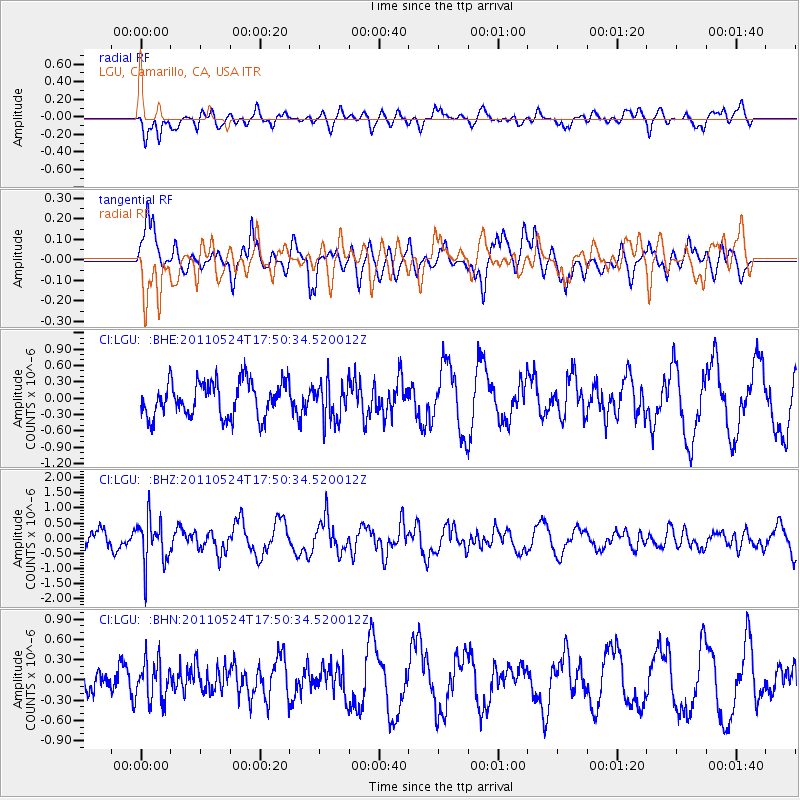
LGU LGU, Camarillo, CA, USA - Earthquake Result Viewer
*The percent match for this event was below the threshold and hence no stack was calculated.
| Earthquake location: |
Andreanof Islands, Aleutian Is. |
| Earthquake latitude/longitude: |
52.6/-173.3 |
| Earthquake time(UTC): |
2011/05/24 (144) 17:43:24 GMT |
| Earthquake Depth: |
138 km |
| Earthquake Magnitude: |
5.6 MB, 5.5 MW, 5.5 MW |
| Earthquake Catalog/Contributor: |
WHDF/NEIC |
|
| Network: |
CI Caltech Regional Seismic Network |
| Station: |
LGU LGU, Camarillo, CA, USA |
| Lat/Lon: |
34.11 N/119.07 W |
| Elevation: |
416 m |
|
| Distance: |
42.4 deg |
| Az: |
93.758 deg |
| Baz: |
312.81 deg |
| Ray Param: |
$rayparam |
*The percent match for this event was below the threshold and hence was not used in the summary stack. |
|
| Radial Match: |
46.50687 % |
| Radial Bump: |
400 |
| Transverse Match: |
54.820263 % |
| Transverse Bump: |
400 |
| SOD ConfigId: |
393008 |
| Insert Time: |
2011-10-28 08:58:00.932 +0000 |
| GWidth: |
2.5 |
| Max Bumps: |
400 |
| Tol: |
0.001 |
|
Signal To Noise
| Channel | StoN | STA | LTA |
| CI:LGU: :BHZ:20110524T17:50:34.520012Z | 2.324375 | 7.523535E-7 | 3.236799E-7 |
| CI:LGU: :BHN:20110524T17:50:34.520012Z | 1.3693445 | 2.9775114E-7 | 2.1744066E-7 |
| CI:LGU: :BHE:20110524T17:50:34.520012Z | 1.0933205 | 3.496386E-7 | 3.1979516E-7 |
| Arrivals |
| Ps | |
| PpPs | |
| PsPs/PpSs | |


