You are here: Home > Network List > CI - Caltech Regional Seismic Network Stations List
> Station MUR Murrieta > Earthquake Result Viewer
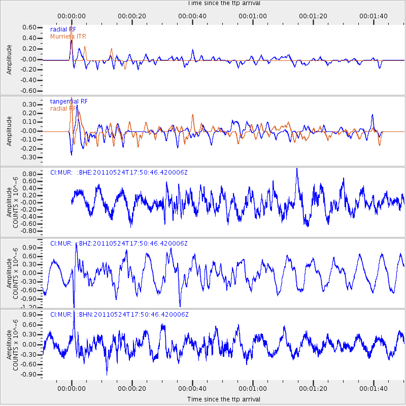
MUR Murrieta - Earthquake Result Viewer
*The percent match for this event was below the threshold and hence no stack was calculated.
| Earthquake location: |
Andreanof Islands, Aleutian Is. |
| Earthquake latitude/longitude: |
52.6/-173.3 |
| Earthquake time(UTC): |
2011/05/24 (144) 17:43:24 GMT |
| Earthquake Depth: |
138 km |
| Earthquake Magnitude: |
5.6 MB, 5.5 MW, 5.5 MW |
| Earthquake Catalog/Contributor: |
WHDF/NEIC |
|
| Network: |
CI Caltech Regional Seismic Network |
| Station: |
MUR Murrieta |
| Lat/Lon: |
33.60 N/117.20 W |
| Elevation: |
562 m |
|
| Distance: |
43.9 deg |
| Az: |
92.749 deg |
| Baz: |
313.111 deg |
| Ray Param: |
$rayparam |
*The percent match for this event was below the threshold and hence was not used in the summary stack. |
|
| Radial Match: |
66.54675 % |
| Radial Bump: |
400 |
| Transverse Match: |
67.42993 % |
| Transverse Bump: |
400 |
| SOD ConfigId: |
393008 |
| Insert Time: |
2011-10-28 08:59:14.648 +0000 |
| GWidth: |
2.5 |
| Max Bumps: |
400 |
| Tol: |
0.001 |
|
Signal To Noise
| Channel | StoN | STA | LTA |
| CI:MUR: :BHZ:20110524T17:50:46.420006Z | 1.1466389 | 4.622283E-7 | 4.0311582E-7 |
| CI:MUR: :BHN:20110524T17:50:46.420006Z | 1.0729299 | 3.2959636E-7 | 3.0719283E-7 |
| CI:MUR: :BHE:20110524T17:50:46.420006Z | 0.9785421 | 2.4001542E-7 | 2.4527858E-7 |
| Arrivals |
| Ps | |
| PpPs | |
| PsPs/PpSs | |


