You are here: Home > Network List > CD - China Digital Seismograph Network Stations List
> Station ENH Enshi, Hubei Province, China > Earthquake Result Viewer
ENH Enshi, Hubei Province, China - Earthquake Result Viewer
| Earthquake location: |
South Of Mariana Islands |
| Earthquake latitude/longitude: |
13.0/144.8 |
| Earthquake time(UTC): |
1993/08/08 (220) 08:34:25 GMT |
| Earthquake Depth: |
61 km |
| Earthquake Magnitude: |
7.2 MB, 8.1 MS, 8.2 UNKNOWN, 7.5 MW |
| Earthquake Catalog/Contributor: |
WHDF/NEIC |
|
| Network: |
CD China Digital Seismograph Network |
| Station: |
ENH Enshi, Hubei Province, China |
| Lat/Lon: |
30.27 N/109.49 E |
| Elevation: |
487 m |
|
| Distance: |
36.9 deg |
| Az: |
303.56 deg |
| Baz: |
110.116 deg |
| Ray Param: |
0.07628736 |
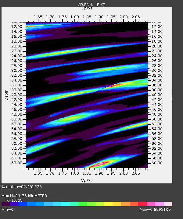
| Estimated Moho Depth: |
11.75 km |
| Estimated Crust Vp/Vs: |
1.61 |
| Assumed Crust Vp: |
6.083 km/s |
| Estimated Crust Vs: |
3.79 km/s |
| Estimated Crust Poisson's Ratio: |
0.18 |
|
| Radial Match: |
92.451225 % |
| Radial Bump: |
400 |
| Transverse Match: |
79.08206 % |
| Transverse Bump: |
400 |
| SOD ConfigId: |
4480 |
| Insert Time: |
2010-02-26 21:20:29.169 +0000 |
| GWidth: |
2.5 |
| Max Bumps: |
400 |
| Tol: |
0.001 |
|

Signal To Noise
| Channel | StoN | STA | LTA |
| CD:ENH: :BHZ:19930808T08:40:57.07901Z | 3.6477163 | 2.9866692E-7 | 8.187778E-8 |
| CD:ENH: :BHN:19930808T08:40:57.07901Z | 1.2172842 | 4.3444107E-8 | 3.568937E-8 |
| CD:ENH: :BHE:19930808T08:40:57.07901Z | 2.2201028 | 1.3719901E-7 | 6.1798495E-8 |
| Arrivals |
| Ps | 1.3 SECOND |
| PpPs | 4.7 SECOND |
| PsPs/PpSs | 5.9 SECOND |


