You are here: Home > Network List > CD - China Digital Seismograph Network Stations List
> Station ENH Enshi, Hubei Province, China > Earthquake Result Viewer
ENH Enshi, Hubei Province, China - Earthquake Result Viewer
| Earthquake location: |
Vanuatu Islands |
| Earthquake latitude/longitude: |
-20.2/169.8 |
| Earthquake time(UTC): |
1993/12/29 (363) 07:48:14 GMT |
| Earthquake Depth: |
33 km |
| Earthquake Magnitude: |
6.1 MB, 6.8 MS, 6.8 UNKNOWN, 7.0 MW |
| Earthquake Catalog/Contributor: |
WHDF/NEIC |
|
| Network: |
CD China Digital Seismograph Network |
| Station: |
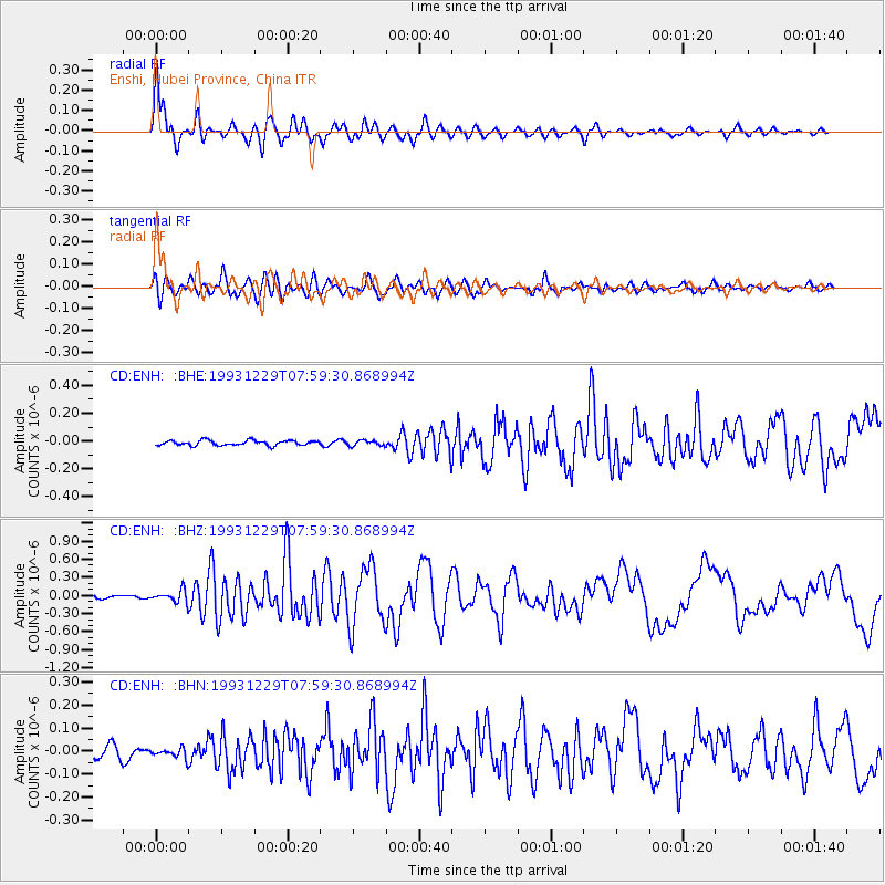
ENH Enshi, Hubei Province, China |
| Lat/Lon: |
30.27 N/109.49 E |
| Elevation: |
487 m |
|
| Distance: |
76.6 deg |
| Az: |
309.451 deg |
| Baz: |
123.021 deg |
| Ray Param: |
0.05080786 |
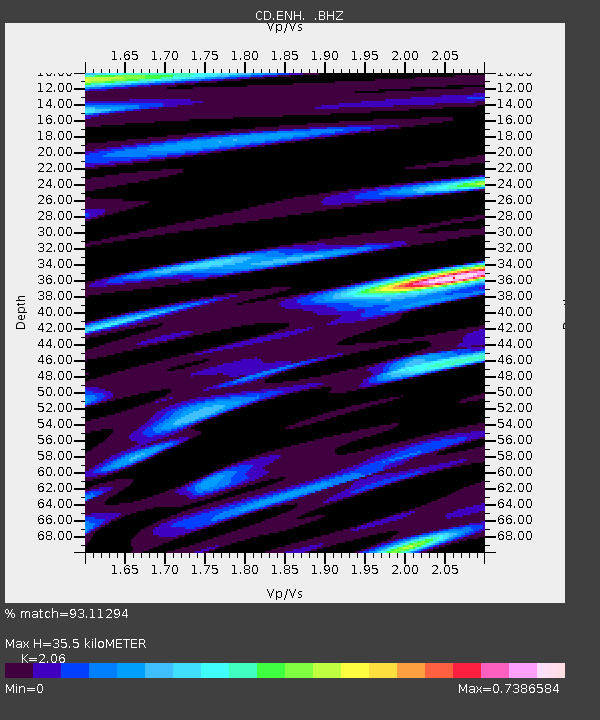
| Estimated Moho Depth: |
35.5 km |
| Estimated Crust Vp/Vs: |
2.06 |
| Assumed Crust Vp: |
6.083 km/s |
| Estimated Crust Vs: |
2.953 km/s |
| Estimated Crust Poisson's Ratio: |
0.35 |
|
| Radial Match: |
93.11294 % |
| Radial Bump: |
400 |
| Transverse Match: |
85.50195 % |
| Transverse Bump: |
400 |
| SOD ConfigId: |
4480 |
| Insert Time: |
2010-02-26 21:20:30.671 +0000 |
| GWidth: |
2.5 |
| Max Bumps: |
400 |
| Tol: |
0.001 |
|
Signal To Noise
| Channel | StoN | STA | LTA |
| CD:ENH: :BHZ:19931229T07:59:30.868994Z | 4.360309 | 1.02112985E-7 | 2.341875E-8 |
| CD:ENH: :BHN:19931229T07:59:30.868994Z | 0.7067665 | 2.1429015E-8 | 3.0319796E-8 |
| CD:ENH: :BHE:19931229T07:59:30.868994Z | 1.0726773 | 1.9232061E-8 | 1.7929029E-8 |
| Arrivals |
| Ps | 6.3 SECOND |
| PpPs | 17 SECOND |
| PsPs/PpSs | 24 SECOND |


