You are here: Home > Network List > CD - China Digital Seismograph Network Stations List
> Station ENH Enshi, Hubei Province, China > Earthquake Result Viewer
ENH Enshi, Hubei Province, China - Earthquake Result Viewer
| Earthquake location: |
South Of Java, Indonesia |
| Earthquake latitude/longitude: |
-10.5/112.9 |
| Earthquake time(UTC): |
1994/06/03 (154) 21:06:57 GMT |
| Earthquake Depth: |
16 km |
| Earthquake Magnitude: |
5.9 MB, 6.4 MS, 6.3 UNKNOWN, 6.6 MW |
| Earthquake Catalog/Contributor: |
WHDF/NEIC |
|
| Network: |
CD China Digital Seismograph Network |
| Station: |
ENH Enshi, Hubei Province, China |
| Lat/Lon: |
30.27 N/109.49 E |
| Elevation: |
487 m |
|
| Distance: |
40.7 deg |
| Az: |
355.5 deg |
| Baz: |
174.883 deg |
| Ray Param: |
0.0742575 |
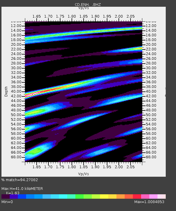
| Estimated Moho Depth: |
41.0 km |
| Estimated Crust Vp/Vs: |
1.63 |
| Assumed Crust Vp: |
6.083 km/s |
| Estimated Crust Vs: |
3.732 km/s |
| Estimated Crust Poisson's Ratio: |
0.20 |
|
| Radial Match: |
94.27082 % |
| Radial Bump: |
400 |
| Transverse Match: |
78.48437 % |
| Transverse Bump: |
400 |
| SOD ConfigId: |
4480 |
| Insert Time: |
2010-02-26 21:20:32.022 +0000 |
| GWidth: |
2.5 |
| Max Bumps: |
400 |
| Tol: |
0.001 |
|
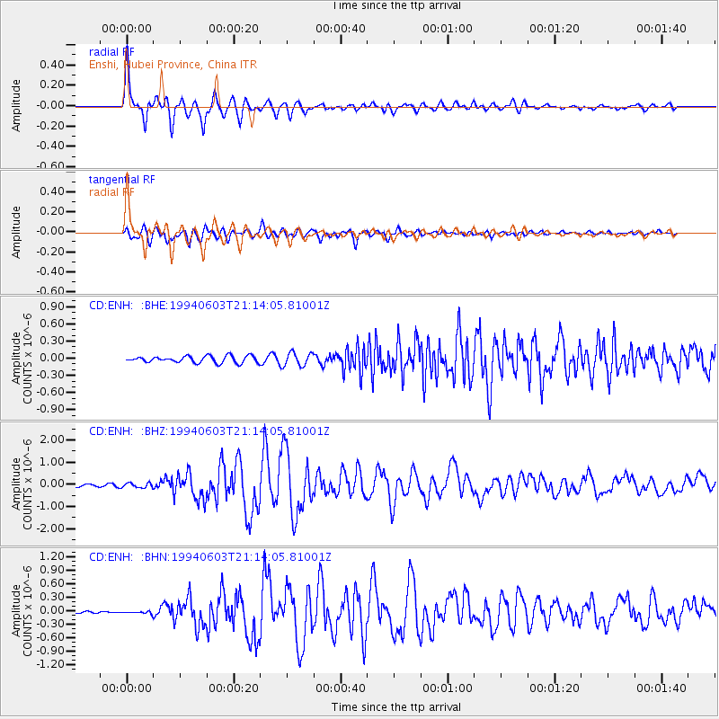
Signal To Noise
| Channel | StoN | STA | LTA |
| CD:ENH: :BHZ:19940603T21:14:05.81001Z | 2.0910184 | 1.05596854E-7 | 5.05002E-8 |
| CD:ENH: :BHN:19940603T21:14:05.81001Z | 1.27998 | 2.8005639E-8 | 2.1879748E-8 |
| CD:ENH: :BHE:19940603T21:14:05.81001Z | 2.0026715 | 1.1650992E-7 | 5.8177253E-8 |
| Arrivals |
| Ps | 4.5 SECOND |
| PpPs | 17 SECOND |
| PsPs/PpSs | 21 SECOND |


