You are here: Home > Network List > TA - USArray Transportable Network (new EarthScope stations) Stations List
> Station T25A Trinidad, CO, USA > Earthquake Result Viewer
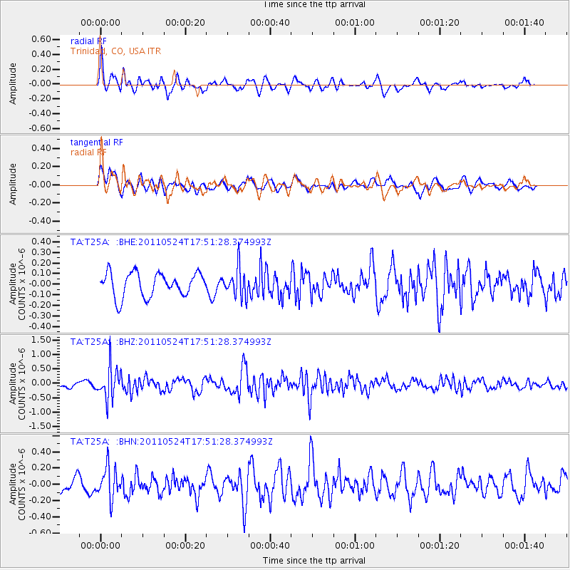
T25A Trinidad, CO, USA - Earthquake Result Viewer
*The percent match for this event was below the threshold and hence no stack was calculated.
| Earthquake location: |
Andreanof Islands, Aleutian Is. |
| Earthquake latitude/longitude: |
52.6/-173.3 |
| Earthquake time(UTC): |
2011/05/24 (144) 17:43:24 GMT |
| Earthquake Depth: |
138 km |
| Earthquake Magnitude: |
5.6 MB, 5.5 MW, 5.5 MW |
| Earthquake Catalog/Contributor: |
WHDF/NEIC |
|
| Network: |
TA USArray Transportable Network (new EarthScope stations) |
| Station: |
T25A Trinidad, CO, USA |
| Lat/Lon: |
37.14 N/104.41 W |
| Elevation: |
2017 m |
|
| Distance: |
49.3 deg |
| Az: |
79.495 deg |
| Baz: |
311.362 deg |
| Ray Param: |
$rayparam |
*The percent match for this event was below the threshold and hence was not used in the summary stack. |
|
| Radial Match: |
71.087395 % |
| Radial Bump: |
400 |
| Transverse Match: |
57.432354 % |
| Transverse Bump: |
400 |
| SOD ConfigId: |
393008 |
| Insert Time: |
2011-10-28 09:09:57.331 +0000 |
| GWidth: |
2.5 |
| Max Bumps: |
400 |
| Tol: |
0.001 |
|
Signal To Noise
| Channel | StoN | STA | LTA |
| TA:T25A: :BHZ:20110524T17:51:28.374993Z | 4.5463896 | 5.6402763E-7 | 1.2406056E-7 |
| TA:T25A: :BHN:20110524T17:51:28.374993Z | 1.758774 | 1.9394965E-7 | 1.1027548E-7 |
| TA:T25A: :BHE:20110524T17:51:28.374993Z | 1.2167076 | 1.3682255E-7 | 1.12453115E-7 |
| Arrivals |
| Ps | |
| PpPs | |
| PsPs/PpSs | |


