You are here: Home > Network List > TA - USArray Transportable Network (new EarthScope stations) Stations List
> Station A26A Wade Farm, Kenmare, ND, USA > Earthquake Result Viewer
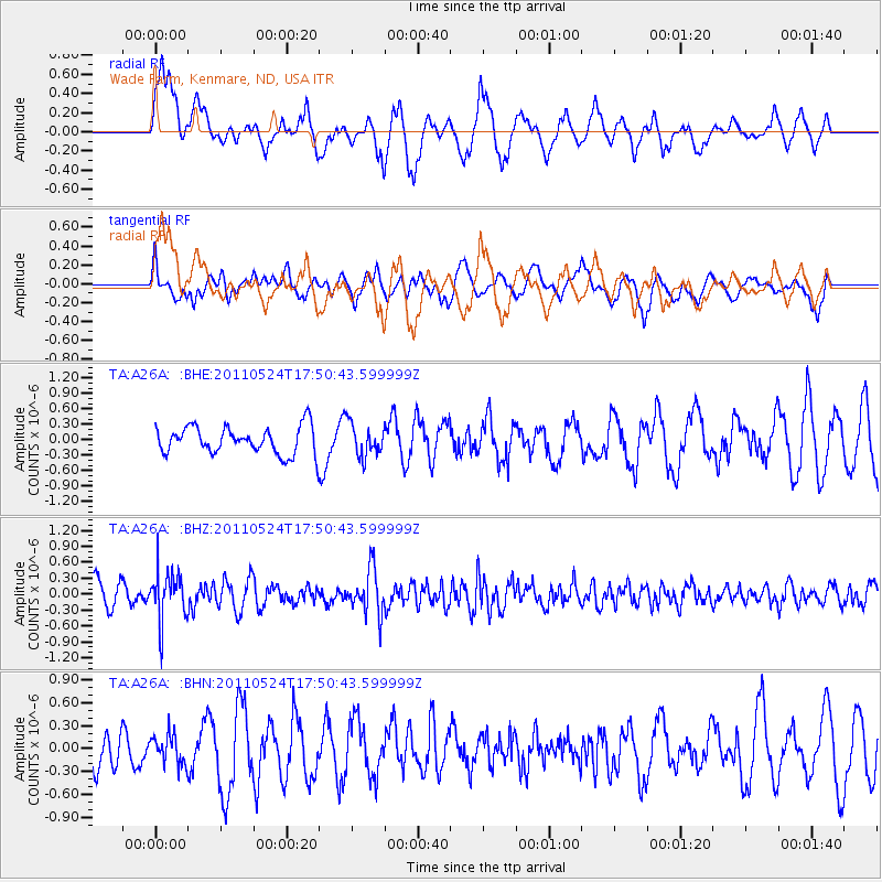
A26A Wade Farm, Kenmare, ND, USA - Earthquake Result Viewer
*The percent match for this event was below the threshold and hence no stack was calculated.
| Earthquake location: |
Andreanof Islands, Aleutian Is. |
| Earthquake latitude/longitude: |
52.6/-173.3 |
| Earthquake time(UTC): |
2011/05/24 (144) 17:43:24 GMT |
| Earthquake Depth: |
138 km |
| Earthquake Magnitude: |
5.6 MB, 5.5 MW, 5.5 MW |
| Earthquake Catalog/Contributor: |
WHDF/NEIC |
|
| Network: |
TA USArray Transportable Network (new EarthScope stations) |
| Station: |
A26A Wade Farm, Kenmare, ND, USA |
| Lat/Lon: |
48.90 N/102.04 W |
| Elevation: |
570 m |
|
| Distance: |
43.5 deg |
| Az: |
65.104 deg |
| Baz: |
303.021 deg |
| Ray Param: |
$rayparam |
*The percent match for this event was below the threshold and hence was not used in the summary stack. |
|
| Radial Match: |
57.948284 % |
| Radial Bump: |
400 |
| Transverse Match: |
56.130375 % |
| Transverse Bump: |
400 |
| SOD ConfigId: |
393008 |
| Insert Time: |
2011-10-28 09:11:27.682 +0000 |
| GWidth: |
2.5 |
| Max Bumps: |
400 |
| Tol: |
0.001 |
|
Signal To Noise
| Channel | StoN | STA | LTA |
| TA:A26A: :BHZ:20110524T17:50:43.599999Z | 2.2226012 | 4.656407E-7 | 2.095026E-7 |
| TA:A26A: :BHN:20110524T17:50:43.599999Z | 0.62953573 | 1.8752995E-7 | 2.9788612E-7 |
| TA:A26A: :BHE:20110524T17:50:43.599999Z | 1.1810871 | 3.1525678E-7 | 2.6692084E-7 |
| Arrivals |
| Ps | |
| PpPs | |
| PsPs/PpSs | |


