You are here: Home > Network List > TA - USArray Transportable Network (new EarthScope stations) Stations List
> Station X33A Lawton, OK, USA > Earthquake Result Viewer
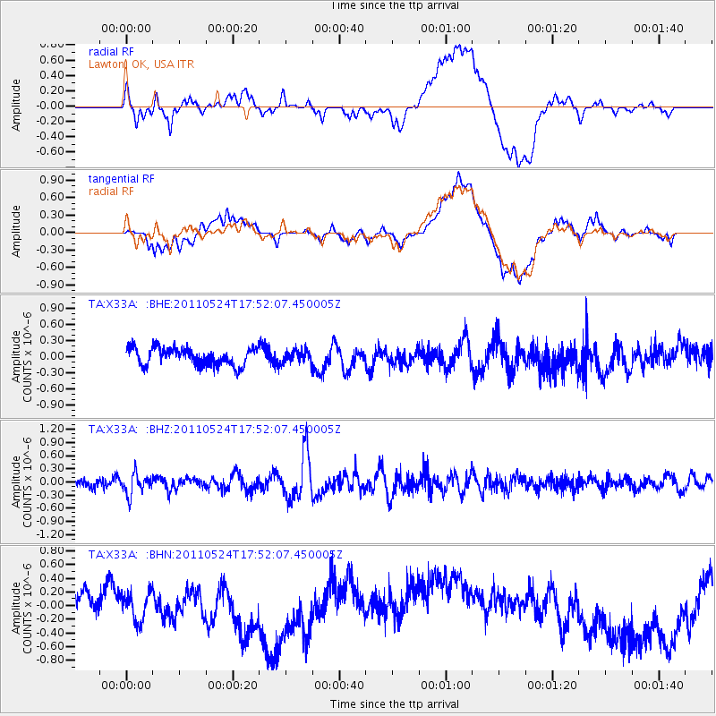
X33A Lawton, OK, USA - Earthquake Result Viewer
*The percent match for this event was below the threshold and hence no stack was calculated.
| Earthquake location: |
Andreanof Islands, Aleutian Is. |
| Earthquake latitude/longitude: |
52.6/-173.3 |
| Earthquake time(UTC): |
2011/05/24 (144) 17:43:24 GMT |
| Earthquake Depth: |
138 km |
| Earthquake Magnitude: |
5.6 MB, 5.5 MW, 5.5 MW |
| Earthquake Catalog/Contributor: |
WHDF/NEIC |
|
| Network: |
TA USArray Transportable Network (new EarthScope stations) |
| Station: |
X33A Lawton, OK, USA |
| Lat/Lon: |
34.54 N/98.50 W |
| Elevation: |
346 m |
|
| Distance: |
54.6 deg |
| Az: |
77.793 deg |
| Baz: |
313.759 deg |
| Ray Param: |
$rayparam |
*The percent match for this event was below the threshold and hence was not used in the summary stack. |
|
| Radial Match: |
27.193981 % |
| Radial Bump: |
400 |
| Transverse Match: |
27.145327 % |
| Transverse Bump: |
400 |
| SOD ConfigId: |
393008 |
| Insert Time: |
2011-10-28 09:13:58.352 +0000 |
| GWidth: |
2.5 |
| Max Bumps: |
400 |
| Tol: |
0.001 |
|
Signal To Noise
| Channel | StoN | STA | LTA |
| TA:X33A: :BHZ:20110524T17:52:07.450005Z | 3.19506 | 2.3584793E-7 | 7.381643E-8 |
| TA:X33A: :BHN:20110524T17:52:07.450005Z | 0.9982608 | 3.0845223E-7 | 3.0898963E-7 |
| TA:X33A: :BHE:20110524T17:52:07.450005Z | 0.6943151 | 1.1220488E-7 | 1.6160514E-7 |
| Arrivals |
| Ps | |
| PpPs | |
| PsPs/PpSs | |


