You are here: Home > Network List > TA - USArray Transportable Network (new EarthScope stations) Stations List
> Station N02D Trinity Center, CA, USA > Earthquake Result Viewer
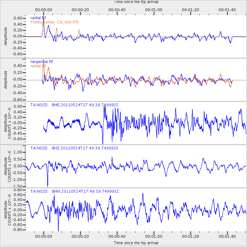
N02D Trinity Center, CA, USA - Earthquake Result Viewer
*The percent match for this event was below the threshold and hence no stack was calculated.
| Earthquake location: |
Andreanof Islands, Aleutian Is. |
| Earthquake latitude/longitude: |
52.6/-173.3 |
| Earthquake time(UTC): |
2011/05/24 (144) 17:43:24 GMT |
| Earthquake Depth: |
138 km |
| Earthquake Magnitude: |
5.6 MB, 5.5 MW, 5.5 MW |
| Earthquake Catalog/Contributor: |
WHDF/NEIC |
|
| Network: |
TA USArray Transportable Network (new EarthScope stations) |
| Station: |
N02D Trinity Center, CA, USA |
| Lat/Lon: |
40.97 N/122.71 W |
| Elevation: |
937 m |
|
| Distance: |
35.8 deg |
| Az: |
88.312 deg |
| Baz: |
306.363 deg |
| Ray Param: |
$rayparam |
*The percent match for this event was below the threshold and hence was not used in the summary stack. |
|
| Radial Match: |
59.575222 % |
| Radial Bump: |
400 |
| Transverse Match: |
45.733105 % |
| Transverse Bump: |
400 |
| SOD ConfigId: |
393008 |
| Insert Time: |
2011-10-28 09:14:32.897 +0000 |
| GWidth: |
2.5 |
| Max Bumps: |
400 |
| Tol: |
0.001 |
|
Signal To Noise
| Channel | StoN | STA | LTA |
| TA:N02D: :BHZ:20110524T17:49:39.749993Z | 3.458689 | 3.8834554E-7 | 1.1228114E-7 |
| TA:N02D: :BHN:20110524T17:49:39.749993Z | 1.2718076 | 2.2747275E-7 | 1.7885783E-7 |
| TA:N02D: :BHE:20110524T17:49:39.749993Z | 2.0524244 | 3.006641E-7 | 1.4649217E-7 |
| Arrivals |
| Ps | |
| PpPs | |
| PsPs/PpSs | |


