You are here: Home > Network List > CD - China Digital Seismograph Network Stations List
> Station ENH Enshi, Hubei Province, China > Earthquake Result Viewer
ENH Enshi, Hubei Province, China - Earthquake Result Viewer

| Earthquake location: |
South Of Java, Indonesia |
| Earthquake latitude/longitude: |
-10.5/113.0 |
| Earthquake time(UTC): |
1994/06/02 (153) 18:17:36 GMT |
| Earthquake Depth: |
39 km |
| Earthquake Magnitude: |
5.5 MB, 7.2 MS, 6.8 UNKNOWN, 7.7 MW |
| Earthquake Catalog/Contributor: |
WHDF/NEIC |
|
| Network: |
CD China Digital Seismograph Network |
| Station: |
ENH Enshi, Hubei Province, China |
| Lat/Lon: |
30.27 N/109.49 E |
| Elevation: |
487 m |
|
| Distance: |
40.6 deg |
| Az: |
355.364 deg |
| Baz: |
174.728 deg |
| Ray Param: |
0.07419121 |
| Estimated Moho Depth: |
39.5 km |
| Estimated Crust Vp/Vs: |
1.69 |
| Assumed Crust Vp: |
6.083 km/s |
| Estimated Crust Vs: |
3.594 km/s |
| Estimated Crust Poisson's Ratio: |
0.23 |
|
| Radial Match: |
97.5794 % |
| Radial Bump: |
400 |
| Transverse Match: |
83.47851 % |
| Transverse Bump: |
400 |
| SOD ConfigId: |
4480 |
| Insert Time: |
2010-02-26 21:20:36.180 +0000 |
| GWidth: |
2.5 |
| Max Bumps: |
400 |
| Tol: |
0.001 |
|
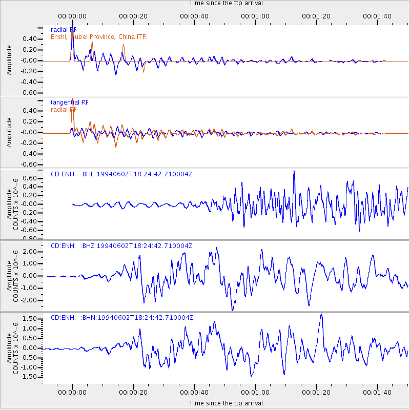
Signal To Noise
| Channel | StoN | STA | LTA |
| CD:ENH: :BHZ:19940602T18:24:42.710004Z | 5.471912 | 8.78995E-8 | 1.6063764E-8 |
| CD:ENH: :BHN:19940602T18:24:42.710004Z | 2.7112536 | 4.6534748E-8 | 1.7163552E-8 |
| CD:ENH: :BHE:19940602T18:24:42.710004Z | 0.6815492 | 2.3812268E-8 | 3.493844E-8 |
| Arrivals |
| Ps | 4.8 SECOND |
| PpPs | 16 SECOND |
| PsPs/PpSs | 21 SECOND |


