You are here: Home > Network List > GS - US Geological Survey Networks Stations List
> Station DEC12 Boyd Road Surface Site > Earthquake Result Viewer
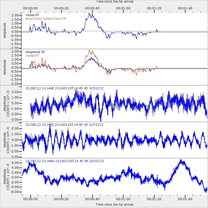
DEC12 Boyd Road Surface Site - Earthquake Result Viewer
*The percent match for this event was below the threshold and hence no stack was calculated.
| Earthquake location: |
Near Coast Of Northern Chile |
| Earthquake latitude/longitude: |
-20.1/-70.8 |
| Earthquake time(UTC): |
2014/03/18 (077) 14:35:58 GMT |
| Earthquake Depth: |
26 km |
| Earthquake Magnitude: |
5.1 MW |
| Earthquake Catalog/Contributor: |
ISC/ISC |
|
| Network: |
GS US Geological Survey Networks |
| Station: |
DEC12 Boyd Road Surface Site |
| Lat/Lon: |
39.91 N/88.91 W |
| Elevation: |
208 m |
|
| Distance: |
62.1 deg |
| Az: |
344.337 deg |
| Baz: |
160.744 deg |
| Ray Param: |
$rayparam |
*The percent match for this event was below the threshold and hence was not used in the summary stack. |
|
| Radial Match: |
15.370309 % |
| Radial Bump: |
400 |
| Transverse Match: |
16.287693 % |
| Transverse Bump: |
400 |
| SOD ConfigId: |
3390531 |
| Insert Time: |
2019-04-10 18:01:31.537 +0000 |
| GWidth: |
2.5 |
| Max Bumps: |
400 |
| Tol: |
0.001 |
|
Signal To Noise
| Channel | StoN | STA | LTA |
| GS:DEC12:01:HHZ:20140318T14:45:45.925022Z | 0.70332575 | 5.192934E-7 | 7.3833974E-7 |
| GS:DEC12:01:HHN:20140318T14:45:45.925022Z | 5.1823583 | 6.501858E-6 | 1.2546138E-6 |
| GS:DEC12:01:HHE:20140318T14:45:45.925022Z | 2.188631 | 1.7461869E-6 | 7.9784434E-7 |
| Arrivals |
| Ps | |
| PpPs | |
| PsPs/PpSs | |


