You are here: Home > Network List > CD - China Digital Seismograph Network Stations List
> Station ENH Enshi, Hubei Province, China > Earthquake Result Viewer
ENH Enshi, Hubei Province, China - Earthquake Result Viewer

| Earthquake location: |
Irian Jaya Region, Indonesia |
| Earthquake latitude/longitude: |
-0.9/137.0 |
| Earthquake time(UTC): |
1996/02/17 (048) 05:59:29 GMT |
| Earthquake Depth: |
33 km |
| Earthquake Magnitude: |
6.5 MB, 8.1 MS, 7.9 UNKNOWN |
| Earthquake Catalog/Contributor: |
WHDF/NEIC |
|
| Network: |
CD China Digital Seismograph Network |
| Station: |
ENH Enshi, Hubei Province, China |
| Lat/Lon: |
30.27 N/109.49 E |
| Elevation: |
487 m |
|
| Distance: |
40.6 deg |
| Az: |
322.117 deg |
| Baz: |
134.79 deg |
| Ray Param: |
0.07421324 |
| Estimated Moho Depth: |
35.0 km |
| Estimated Crust Vp/Vs: |
2.09 |
| Assumed Crust Vp: |
6.083 km/s |
| Estimated Crust Vs: |
2.907 km/s |
| Estimated Crust Poisson's Ratio: |
0.35 |
|
| Radial Match: |
93.52031 % |
| Radial Bump: |
400 |
| Transverse Match: |
79.197205 % |
| Transverse Bump: |
400 |
| SOD ConfigId: |
4480 |
| Insert Time: |
2010-02-26 21:20:37.434 +0000 |
| GWidth: |
2.5 |
| Max Bumps: |
400 |
| Tol: |
0.001 |
|
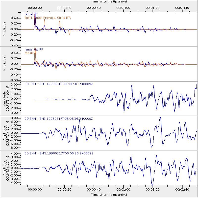
Signal To Noise
| Channel | StoN | STA | LTA |
| CD:ENH: :BHZ:19960217T06:06:36.240009Z | 4.907033 | 1.7368698E-7 | 3.5395523E-8 |
| CD:ENH: :BHN:19960217T06:06:36.240009Z | 2.9153268 | 7.0473924E-8 | 2.4173593E-8 |
| CD:ENH: :BHE:19960217T06:06:36.240009Z | 2.287418 | 5.084075E-8 | 2.2226263E-8 |
| Arrivals |
| Ps | 6.6 SECOND |
| PpPs | 17 SECOND |
| PsPs/PpSs | 24 SECOND |


