You are here: Home > Network List > CD - China Digital Seismograph Network Stations List
> Station ENH Enshi, Hubei Province, China > Earthquake Result Viewer
ENH Enshi, Hubei Province, China - Earthquake Result Viewer

| Earthquake location: |
Tonga Islands |
| Earthquake latitude/longitude: |
-19.2/-174.8 |
| Earthquake time(UTC): |
1997/01/03 (003) 03:58:22 GMT |
| Earthquake Depth: |
140 km |
| Earthquake Magnitude: |
5.7 MB, 6.0 UNKNOWN, 6.0 MW |
| Earthquake Catalog/Contributor: |
WHDF/NEIC |
|
| Network: |
CD China Digital Seismograph Network |
| Station: |
ENH Enshi, Hubei Province, China |
| Lat/Lon: |
30.27 N/109.49 E |
| Elevation: |
487 m |
|
| Distance: |
87.8 deg |
| Az: |
302.984 deg |
| Baz: |
113.622 deg |
| Ray Param: |
0.0427368 |
| Estimated Moho Depth: |
36.0 km |
| Estimated Crust Vp/Vs: |
2.02 |
| Assumed Crust Vp: |
6.083 km/s |
| Estimated Crust Vs: |
3.019 km/s |
| Estimated Crust Poisson's Ratio: |
0.34 |
|
| Radial Match: |
86.15018 % |
| Radial Bump: |
400 |
| Transverse Match: |
85.90612 % |
| Transverse Bump: |
400 |
| SOD ConfigId: |
4480 |
| Insert Time: |
2010-02-26 21:20:40.104 +0000 |
| GWidth: |
2.5 |
| Max Bumps: |
400 |
| Tol: |
0.001 |
|
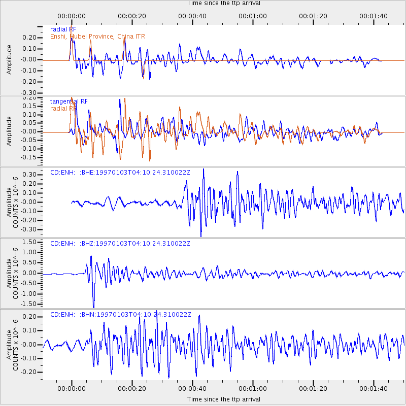
Signal To Noise
| Channel | StoN | STA | LTA |
| CD:ENH: :BHZ:19970103T04:10:24.310022Z | 3.8190975 | 7.17305E-8 | 1.8782053E-8 |
| CD:ENH: :BHN:19970103T04:10:24.310022Z | 1.5257145 | 2.660677E-8 | 1.7438891E-8 |
| CD:ENH: :BHE:19970103T04:10:24.310022Z | 0.69351166 | 1.894456E-8 | 2.731686E-8 |
| Arrivals |
| Ps | 6.1 SECOND |
| PpPs | 18 SECOND |
| PsPs/PpSs | 24 SECOND |


