You are here: Home > Network List > TA - USArray Transportable Network (new EarthScope stations) Stations List
> Station Z47A Carrollton, AL, USA > Earthquake Result Viewer
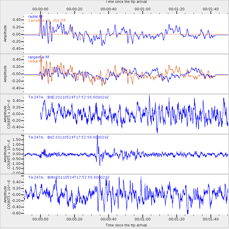
Z47A Carrollton, AL, USA - Earthquake Result Viewer
*The percent match for this event was below the threshold and hence no stack was calculated.
| Earthquake location: |
Andreanof Islands, Aleutian Is. |
| Earthquake latitude/longitude: |
52.6/-173.3 |
| Earthquake time(UTC): |
2011/05/24 (144) 17:43:24 GMT |
| Earthquake Depth: |
138 km |
| Earthquake Magnitude: |
5.6 MB, 5.5 MW, 5.5 MW |
| Earthquake Catalog/Contributor: |
WHDF/NEIC |
|
| Network: |
TA USArray Transportable Network (new EarthScope stations) |
| Station: |
Z47A Carrollton, AL, USA |
| Lat/Lon: |
33.20 N/88.07 W |
| Elevation: |
65 m |
|
| Distance: |
61.7 deg |
| Az: |
71.677 deg |
| Baz: |
316.318 deg |
| Ray Param: |
$rayparam |
*The percent match for this event was below the threshold and hence was not used in the summary stack. |
|
| Radial Match: |
55.58089 % |
| Radial Bump: |
400 |
| Transverse Match: |
47.315414 % |
| Transverse Bump: |
400 |
| SOD ConfigId: |
393008 |
| Insert Time: |
2011-10-28 09:27:56.029 +0000 |
| GWidth: |
2.5 |
| Max Bumps: |
400 |
| Tol: |
0.001 |
|
Signal To Noise
| Channel | StoN | STA | LTA |
| TA:Z47A: :BHZ:20110524T17:52:56.600029Z | 2.414511 | 2.1949607E-7 | 9.090705E-8 |
| TA:Z47A: :BHN:20110524T17:52:56.600029Z | 1.149911 | 1.6750221E-7 | 1.4566537E-7 |
| TA:Z47A: :BHE:20110524T17:52:56.600029Z | 1.099447 | 1.6365735E-7 | 1.4885423E-7 |
| Arrivals |
| Ps | |
| PpPs | |
| PsPs/PpSs | |


