You are here: Home > Network List > TA - USArray Transportable Network (new EarthScope stations) Stations List
> Station W45A Hickory Valley, TN, USA > Earthquake Result Viewer
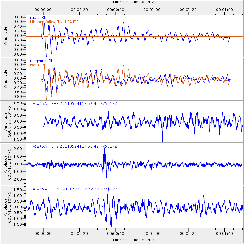
W45A Hickory Valley, TN, USA - Earthquake Result Viewer
*The percent match for this event was below the threshold and hence no stack was calculated.
| Earthquake location: |
Andreanof Islands, Aleutian Is. |
| Earthquake latitude/longitude: |
52.6/-173.3 |
| Earthquake time(UTC): |
2011/05/24 (144) 17:43:24 GMT |
| Earthquake Depth: |
138 km |
| Earthquake Magnitude: |
5.6 MB, 5.5 MW, 5.5 MW |
| Earthquake Catalog/Contributor: |
WHDF/NEIC |
|
| Network: |
TA USArray Transportable Network (new EarthScope stations) |
| Station: |
W45A Hickory Valley, TN, USA |
| Lat/Lon: |
35.16 N/89.19 W |
| Elevation: |
187 m |
|
| Distance: |
59.6 deg |
| Az: |
70.877 deg |
| Baz: |
315.301 deg |
| Ray Param: |
$rayparam |
*The percent match for this event was below the threshold and hence was not used in the summary stack. |
|
| Radial Match: |
62.590614 % |
| Radial Bump: |
400 |
| Transverse Match: |
57.62455 % |
| Transverse Bump: |
400 |
| SOD ConfigId: |
393008 |
| Insert Time: |
2011-10-28 09:28:34.871 +0000 |
| GWidth: |
2.5 |
| Max Bumps: |
400 |
| Tol: |
0.001 |
|
Signal To Noise
| Channel | StoN | STA | LTA |
| TA:W45A: :BHZ:20110524T17:52:42.775017Z | 2.1522133 | 2.7045374E-7 | 1.2566306E-7 |
| TA:W45A: :BHN:20110524T17:52:42.775017Z | 1.5259349 | 4.942382E-7 | 3.2389207E-7 |
| TA:W45A: :BHE:20110524T17:52:42.775017Z | 1.1399227 | 2.8559916E-7 | 2.5054254E-7 |
| Arrivals |
| Ps | |
| PpPs | |
| PsPs/PpSs | |


