You are here: Home > Network List > TA - USArray Transportable Network (new EarthScope stations) Stations List
> Station X43A Marvell, AR, USA > Earthquake Result Viewer
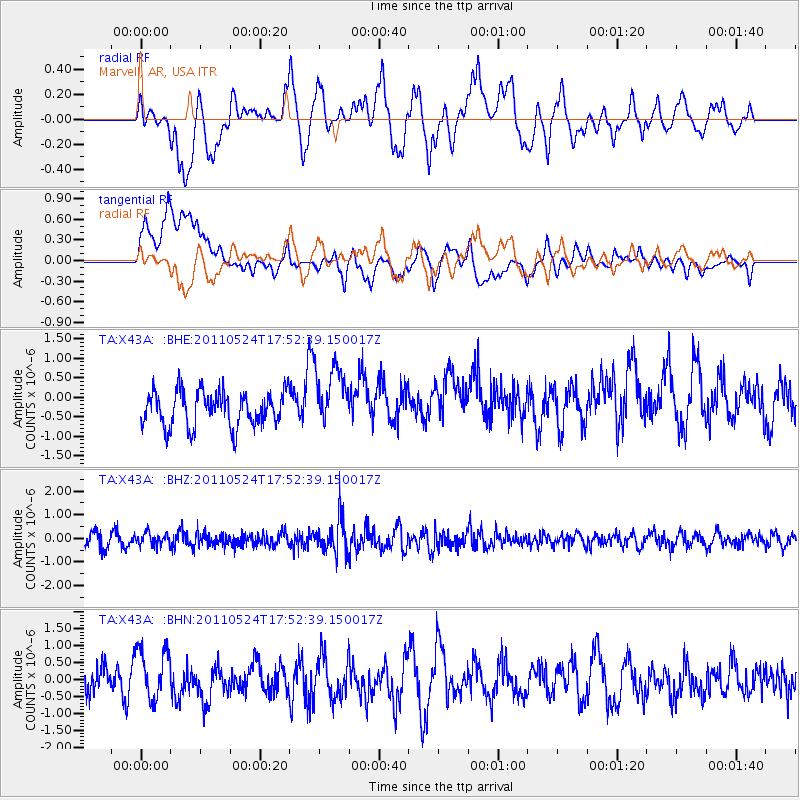
X43A Marvell, AR, USA - Earthquake Result Viewer
*The percent match for this event was below the threshold and hence no stack was calculated.
| Earthquake location: |
Andreanof Islands, Aleutian Is. |
| Earthquake latitude/longitude: |
52.6/-173.3 |
| Earthquake time(UTC): |
2011/05/24 (144) 17:43:24 GMT |
| Earthquake Depth: |
138 km |
| Earthquake Magnitude: |
5.6 MB, 5.5 MW, 5.5 MW |
| Earthquake Catalog/Contributor: |
WHDF/NEIC |
|
| Network: |
TA USArray Transportable Network (new EarthScope stations) |
| Station: |
X43A Marvell, AR, USA |
| Lat/Lon: |
34.52 N/90.88 W |
| Elevation: |
53 m |
|
| Distance: |
59.1 deg |
| Az: |
72.549 deg |
| Baz: |
315.19 deg |
| Ray Param: |
$rayparam |
*The percent match for this event was below the threshold and hence was not used in the summary stack. |
|
| Radial Match: |
54.42667 % |
| Radial Bump: |
400 |
| Transverse Match: |
58.2552 % |
| Transverse Bump: |
400 |
| SOD ConfigId: |
393008 |
| Insert Time: |
2011-10-28 09:28:45.147 +0000 |
| GWidth: |
2.5 |
| Max Bumps: |
400 |
| Tol: |
0.001 |
|
Signal To Noise
| Channel | StoN | STA | LTA |
| TA:X43A: :BHZ:20110524T17:52:39.150017Z | 0.9742956 | 2.67815E-7 | 2.7488068E-7 |
| TA:X43A: :BHN:20110524T17:52:39.150017Z | 1.8427609 | 7.6613514E-7 | 4.1575396E-7 |
| TA:X43A: :BHE:20110524T17:52:39.150017Z | 1.7706034 | 7.9447676E-7 | 4.48704E-7 |
| Arrivals |
| Ps | |
| PpPs | |
| PsPs/PpSs | |


