You are here: Home > Network List > TA - USArray Transportable Network (new EarthScope stations) Stations List
> Station 334A Lometa, TX, USA > Earthquake Result Viewer
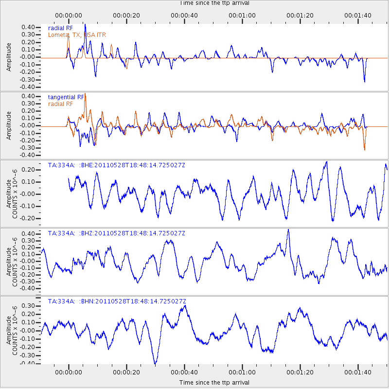
334A Lometa, TX, USA - Earthquake Result Viewer
*The percent match for this event was below the threshold and hence no stack was calculated.
| Earthquake location: |
Kermadec Islands Region |
| Earthquake latitude/longitude: |
-27.5/-178.5 |
| Earthquake time(UTC): |
2011/05/28 (148) 18:35:52 GMT |
| Earthquake Depth: |
307 km |
| Earthquake Magnitude: |
5.5 MW, 5.3 MB |
| Earthquake Catalog/Contributor: |
WHDF/NEIC |
|
| Network: |
TA USArray Transportable Network (new EarthScope stations) |
| Station: |
334A Lometa, TX, USA |
| Lat/Lon: |
31.33 N/98.24 W |
| Elevation: |
389 m |
|
| Distance: |
96.3 deg |
| Az: |
58.052 deg |
| Baz: |
241.775 deg |
| Ray Param: |
$rayparam |
*The percent match for this event was below the threshold and hence was not used in the summary stack. |
|
| Radial Match: |
76.67245 % |
| Radial Bump: |
400 |
| Transverse Match: |
60.00546 % |
| Transverse Bump: |
400 |
| SOD ConfigId: |
393008 |
| Insert Time: |
2011-10-31 23:32:29.459 +0000 |
| GWidth: |
2.5 |
| Max Bumps: |
400 |
| Tol: |
0.001 |
|
Signal To Noise
| Channel | StoN | STA | LTA |
| TA:334A: :BHZ:20110528T18:48:14.725027Z | 0.71126276 | 8.627468E-8 | 1.212979E-7 |
| TA:334A: :BHN:20110528T18:48:14.725027Z | 1.098362 | 8.175824E-8 | 7.4436514E-8 |
| TA:334A: :BHE:20110528T18:48:14.725027Z | 1.4834492 | 1.0698544E-7 | 7.2119384E-8 |
| Arrivals |
| Ps | |
| PpPs | |
| PsPs/PpSs | |


