You are here: Home > Network List > TA - USArray Transportable Network (new EarthScope stations) Stations List
> Station L04D Klamath Falls, OR, USA > Earthquake Result Viewer
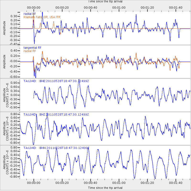
L04D Klamath Falls, OR, USA - Earthquake Result Viewer
*The percent match for this event was below the threshold and hence no stack was calculated.
| Earthquake location: |
Kermadec Islands Region |
| Earthquake latitude/longitude: |
-27.5/-178.5 |
| Earthquake time(UTC): |
2011/05/28 (148) 18:35:52 GMT |
| Earthquake Depth: |
307 km |
| Earthquake Magnitude: |
5.5 MW, 5.3 MB |
| Earthquake Catalog/Contributor: |
WHDF/NEIC |
|
| Network: |
TA USArray Transportable Network (new EarthScope stations) |
| Station: |
L04D Klamath Falls, OR, USA |
| Lat/Lon: |
42.22 N/122.30 W |
| Elevation: |
1437 m |
|
| Distance: |
86.6 deg |
| Az: |
38.213 deg |
| Baz: |
227.725 deg |
| Ray Param: |
$rayparam |
*The percent match for this event was below the threshold and hence was not used in the summary stack. |
|
| Radial Match: |
53.59584 % |
| Radial Bump: |
400 |
| Transverse Match: |
66.05224 % |
| Transverse Bump: |
400 |
| SOD ConfigId: |
393008 |
| Insert Time: |
2011-10-31 23:33:23.334 +0000 |
| GWidth: |
2.5 |
| Max Bumps: |
400 |
| Tol: |
0.001 |
|
Signal To Noise
| Channel | StoN | STA | LTA |
| TA:L04D: :BHZ:20110528T18:47:30.12499Z | 1.6460387 | 4.7001848E-7 | 2.855452E-7 |
| TA:L04D: :BHN:20110528T18:47:30.12499Z | 0.7778684 | 2.531985E-7 | 3.2550298E-7 |
| TA:L04D: :BHE:20110528T18:47:30.12499Z | 1.7698983 | 6.1748926E-7 | 3.4888402E-7 |
| Arrivals |
| Ps | |
| PpPs | |
| PsPs/PpSs | |


