You are here: Home > Network List > UW - Pacific Northwest Regional Seismic Network Stations List
> Station LEBA Lebam, WA, USA > Earthquake Result Viewer
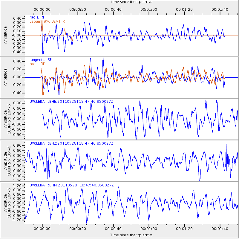
LEBA Lebam, WA, USA - Earthquake Result Viewer
*The percent match for this event was below the threshold and hence no stack was calculated.
| Earthquake location: |
Kermadec Islands Region |
| Earthquake latitude/longitude: |
-27.5/-178.5 |
| Earthquake time(UTC): |
2011/05/28 (148) 18:35:52 GMT |
| Earthquake Depth: |
307 km |
| Earthquake Magnitude: |
5.5 MW, 5.3 MB |
| Earthquake Catalog/Contributor: |
WHDF/NEIC |
|
| Network: |
UW Pacific Northwest Regional Seismic Network |
| Station: |
LEBA Lebam, WA, USA |
| Lat/Lon: |
46.55 N/123.56 W |
| Elevation: |
73 m |
|
| Distance: |
88.9 deg |
| Az: |
34.421 deg |
| Baz: |
226.695 deg |
| Ray Param: |
$rayparam |
*The percent match for this event was below the threshold and hence was not used in the summary stack. |
|
| Radial Match: |
46.405544 % |
| Radial Bump: |
400 |
| Transverse Match: |
44.672527 % |
| Transverse Bump: |
400 |
| SOD ConfigId: |
393008 |
| Insert Time: |
2011-10-31 23:35:01.708 +0000 |
| GWidth: |
2.5 |
| Max Bumps: |
400 |
| Tol: |
0.001 |
|
Signal To Noise
| Channel | StoN | STA | LTA |
| UW:LEBA: :BHZ:20110528T18:47:40.850027Z | 2.0029447 | 4.680027E-7 | 2.3365733E-7 |
| UW:LEBA: :BHN:20110528T18:47:40.850027Z | 1.0454717 | 4.884977E-7 | 4.6725103E-7 |
| UW:LEBA: :BHE:20110528T18:47:40.850027Z | 0.49768418 | 1.8107438E-7 | 3.6383392E-7 |
| Arrivals |
| Ps | |
| PpPs | |
| PsPs/PpSs | |


