You are here: Home > Network List > TA - USArray Transportable Network (new EarthScope stations) Stations List
> Station Z41A Richland Creek Farm, El Dorado, AR, USA > Earthquake Result Viewer
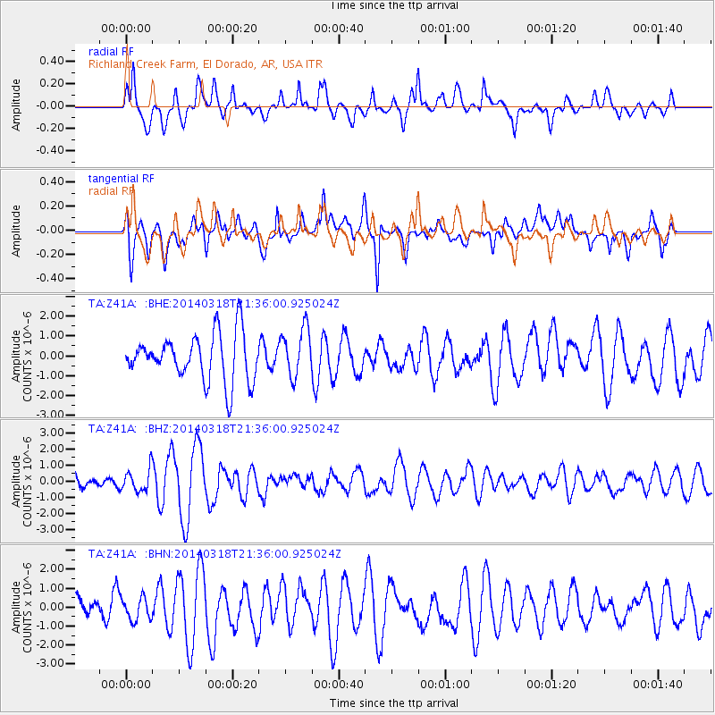
Z41A Richland Creek Farm, El Dorado, AR, USA - Earthquake Result Viewer
*The percent match for this event was below the threshold and hence no stack was calculated.
| Earthquake location: |
Near Coast Of Northern Chile |
| Earthquake latitude/longitude: |
-20.0/-70.8 |
| Earthquake time(UTC): |
2014/03/18 (077) 21:26:45 GMT |
| Earthquake Depth: |
3.8 km |
| Earthquake Magnitude: |
5.8 MWW, 5.9 MWC, 6.0 MWR, 6.0 MWB |
| Earthquake Catalog/Contributor: |
NEIC PDE/NEIC COMCAT |
|
| Network: |
TA USArray Transportable Network (new EarthScope stations) |
| Station: |
Z41A Richland Creek Farm, El Dorado, AR, USA |
| Lat/Lon: |
33.26 N/92.80 W |
| Elevation: |
62 m |
|
| Distance: |
57.0 deg |
| Az: |
337.987 deg |
| Baz: |
155.116 deg |
| Ray Param: |
$rayparam |
*The percent match for this event was below the threshold and hence was not used in the summary stack. |
|
| Radial Match: |
61.56853 % |
| Radial Bump: |
400 |
| Transverse Match: |
50.71141 % |
| Transverse Bump: |
400 |
| SOD ConfigId: |
3390531 |
| Insert Time: |
2019-04-10 18:11:56.660 +0000 |
| GWidth: |
2.5 |
| Max Bumps: |
400 |
| Tol: |
0.001 |
|
Signal To Noise
| Channel | StoN | STA | LTA |
| TA:Z41A: :BHZ:20140318T21:36:00.925024Z | 2.3110723 | 7.092447E-7 | 3.068899E-7 |
| TA:Z41A: :BHN:20140318T21:36:00.925024Z | 0.9171812 | 5.856579E-7 | 6.385411E-7 |
| TA:Z41A: :BHE:20140318T21:36:00.925024Z | 1.055721 | 1.2526667E-6 | 1.1865509E-6 |
| Arrivals |
| Ps | |
| PpPs | |
| PsPs/PpSs | |


