You are here: Home > Network List > TA - USArray Transportable Network (new EarthScope stations) Stations List
> Station D28A Regan, ND, USA > Earthquake Result Viewer
D28A Regan, ND, USA - Earthquake Result Viewer
| Earthquake location: |
Near Coast Of Central Chile |
| Earthquake latitude/longitude: |
-37.6/-73.7 |
| Earthquake time(UTC): |
2011/06/01 (152) 12:55:22 GMT |
| Earthquake Depth: |
21 km |
| Earthquake Magnitude: |
5.6 MB, 6.2 MS, 6.3 MW, 6.3 MW |
| Earthquake Catalog/Contributor: |
WHDF/NEIC |
|
| Network: |
TA USArray Transportable Network (new EarthScope stations) |
| Station: |
D28A Regan, ND, USA |
| Lat/Lon: |
47.19 N/100.57 W |
| Elevation: |
621 m |
|
| Distance: |
87.8 deg |
| Az: |
342.028 deg |
| Baz: |
158.933 deg |
| Ray Param: |
0.04307479 |
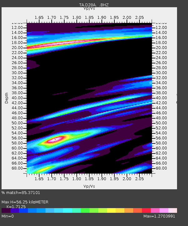
| Estimated Moho Depth: |
56.25 km |
| Estimated Crust Vp/Vs: |
1.71 |
| Assumed Crust Vp: |
6.438 km/s |
| Estimated Crust Vs: |
3.759 km/s |
| Estimated Crust Poisson's Ratio: |
0.24 |
|
| Radial Match: |
85.37101 % |
| Radial Bump: |
324 |
| Transverse Match: |
60.119812 % |
| Transverse Bump: |
379 |
| SOD ConfigId: |
393008 |
| Insert Time: |
2011-10-31 23:55:07.169 +0000 |
| GWidth: |
2.5 |
| Max Bumps: |
400 |
| Tol: |
0.001 |
|

Signal To Noise
| Channel | StoN | STA | LTA |
| TA:D28A: :BHZ:20110601T13:07:38.174983Z | 4.1582313 | 6.145596E-7 | 1.4779351E-7 |
| TA:D28A: :BHN:20110601T13:07:38.174983Z | 0.7704236 | 2.8066373E-7 | 3.6429793E-7 |
| TA:D28A: :BHE:20110601T13:07:38.174983Z | 1.2178704 | 4.4855904E-7 | 3.6831426E-7 |
| Arrivals |
| Ps | 6.4 SECOND |
| PpPs | 23 SECOND |
| PsPs/PpSs | 30 SECOND |


