You are here: Home > Network List > TA - USArray Transportable Network (new EarthScope stations) Stations List
> Station C28A Hausauer Farms, Kief, ND, USA > Earthquake Result Viewer
C28A Hausauer Farms, Kief, ND, USA - Earthquake Result Viewer
| Earthquake location: |
Near Coast Of Central Chile |
| Earthquake latitude/longitude: |
-37.6/-73.7 |
| Earthquake time(UTC): |
2011/06/01 (152) 12:55:22 GMT |
| Earthquake Depth: |
21 km |
| Earthquake Magnitude: |
5.6 MB, 6.2 MS, 6.3 MW, 6.3 MW |
| Earthquake Catalog/Contributor: |
WHDF/NEIC |
|
| Network: |
TA USArray Transportable Network (new EarthScope stations) |
| Station: |
C28A Hausauer Farms, Kief, ND, USA |
| Lat/Lon: |
47.72 N/100.39 W |
| Elevation: |
524 m |
|
| Distance: |
88.2 deg |
| Az: |
342.331 deg |
| Baz: |
159.077 deg |
| Ray Param: |
0.042744834 |
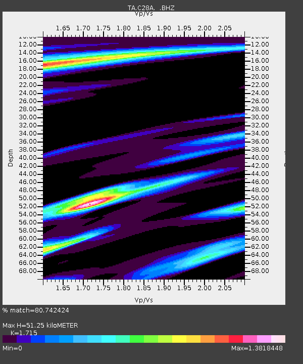
| Estimated Moho Depth: |
51.25 km |
| Estimated Crust Vp/Vs: |
1.72 |
| Assumed Crust Vp: |
6.438 km/s |
| Estimated Crust Vs: |
3.754 km/s |
| Estimated Crust Poisson's Ratio: |
0.24 |
|
| Radial Match: |
80.742424 % |
| Radial Bump: |
393 |
| Transverse Match: |
66.96799 % |
| Transverse Bump: |
400 |
| SOD ConfigId: |
393008 |
| Insert Time: |
2011-10-31 23:55:47.021 +0000 |
| GWidth: |
2.5 |
| Max Bumps: |
400 |
| Tol: |
0.001 |
|

Signal To Noise
| Channel | StoN | STA | LTA |
| TA:C28A: :BHZ:20110601T13:07:40.299983Z | 4.735729 | 4.4095017E-7 | 9.311135E-8 |
| TA:C28A: :BHN:20110601T13:07:40.299983Z | 1.3313177 | 2.5790223E-7 | 1.9371953E-7 |
| TA:C28A: :BHE:20110601T13:07:40.299983Z | 0.6624277 | 2.9873235E-7 | 4.5096596E-7 |
| Arrivals |
| Ps | 5.8 SECOND |
| PpPs | 21 SECOND |
| PsPs/PpSs | 27 SECOND |


