You are here: Home > Network List > TA - USArray Transportable Network (new EarthScope stations) Stations List
> Station B30A Myrvik Farm, Edmore, ND, USA > Earthquake Result Viewer
B30A Myrvik Farm, Edmore, ND, USA - Earthquake Result Viewer

| Earthquake location: |
Near Coast Of Central Chile |
| Earthquake latitude/longitude: |
-37.6/-73.7 |
| Earthquake time(UTC): |
2011/06/01 (152) 12:55:22 GMT |
| Earthquake Depth: |
21 km |
| Earthquake Magnitude: |
5.6 MB, 6.2 MS, 6.3 MW, 6.3 MW |
| Earthquake Catalog/Contributor: |
WHDF/NEIC |
|
| Network: |
TA USArray Transportable Network (new EarthScope stations) |
| Station: |
B30A Myrvik Farm, Edmore, ND, USA |
| Lat/Lon: |
48.45 N/98.33 W |
| Elevation: |
480 m |
|
| Distance: |
88.4 deg |
| Az: |
343.88 deg |
| Baz: |
160.65 deg |
| Ray Param: |
0.042584997 |
| Estimated Moho Depth: |
10.0 km |
| Estimated Crust Vp/Vs: |
1.60 |
| Assumed Crust Vp: |
6.53 km/s |
| Estimated Crust Vs: |
4.082 km/s |
| Estimated Crust Poisson's Ratio: |
0.18 |
|
| Radial Match: |
84.215004 % |
| Radial Bump: |
400 |
| Transverse Match: |
74.76218 % |
| Transverse Bump: |
400 |
| SOD ConfigId: |
393008 |
| Insert Time: |
2011-10-31 23:56:05.703 +0000 |
| GWidth: |
2.5 |
| Max Bumps: |
400 |
| Tol: |
0.001 |
|
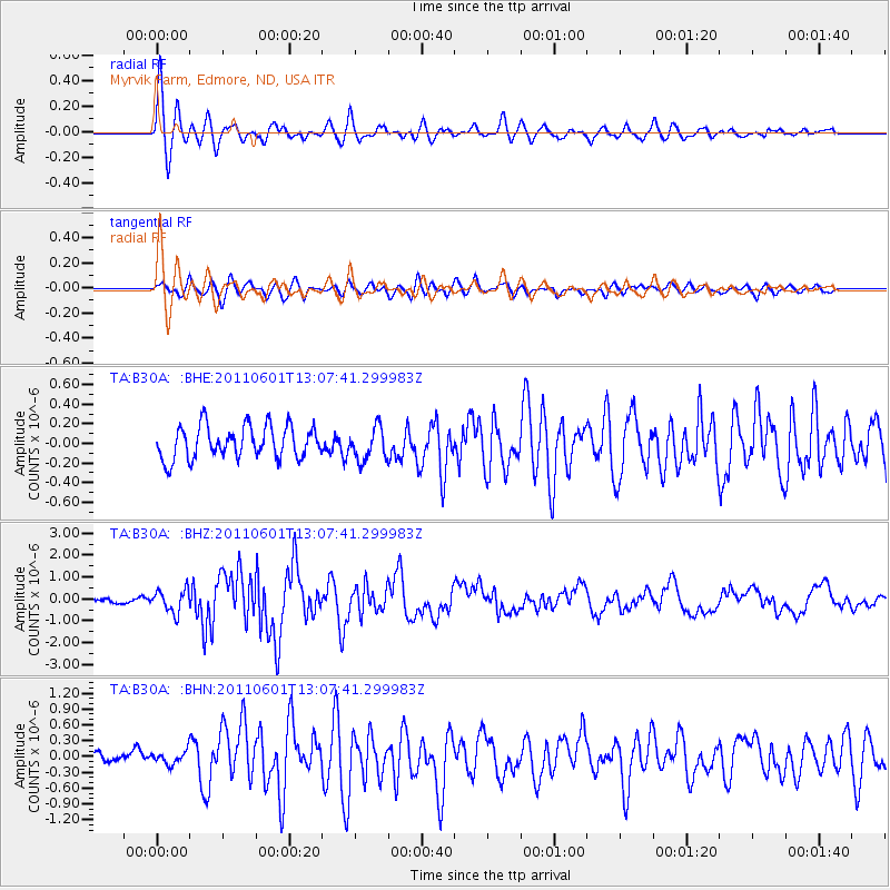
Signal To Noise
| Channel | StoN | STA | LTA |
| TA:B30A: :BHZ:20110601T13:07:41.299983Z | 4.9466763 | 5.1559994E-7 | 1.04231596E-7 |
| TA:B30A: :BHN:20110601T13:07:41.299983Z | 0.5799483 | 1.245131E-7 | 2.1469687E-7 |
| TA:B30A: :BHE:20110601T13:07:41.299983Z | 1.014289 | 1.6727107E-7 | 1.649146E-7 |
| Arrivals |
| Ps | 0.9 SECOND |
| PpPs | 3.9 SECOND |
| PsPs/PpSs | 4.8 SECOND |


