You are here: Home > Network List > TA - USArray Transportable Network (new EarthScope stations) Stations List
> Station H29A Onida, SD, USA > Earthquake Result Viewer
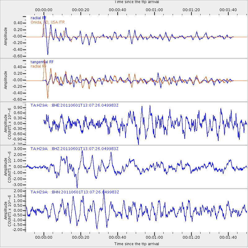
H29A Onida, SD, USA - Earthquake Result Viewer
*The percent match for this event was below the threshold and hence no stack was calculated.
| Earthquake location: |
Near Coast Of Central Chile |
| Earthquake latitude/longitude: |
-37.6/-73.7 |
| Earthquake time(UTC): |
2011/06/01 (152) 12:55:22 GMT |
| Earthquake Depth: |
21 km |
| Earthquake Magnitude: |
5.6 MB, 6.2 MS, 6.3 MW, 6.3 MW |
| Earthquake Catalog/Contributor: |
WHDF/NEIC |
|
| Network: |
TA USArray Transportable Network (new EarthScope stations) |
| Station: |
H29A Onida, SD, USA |
| Lat/Lon: |
44.63 N/100.21 W |
| Elevation: |
548 m |
|
| Distance: |
85.3 deg |
| Az: |
341.341 deg |
| Baz: |
159.146 deg |
| Ray Param: |
$rayparam |
*The percent match for this event was below the threshold and hence was not used in the summary stack. |
|
| Radial Match: |
78.86095 % |
| Radial Bump: |
400 |
| Transverse Match: |
70.10513 % |
| Transverse Bump: |
400 |
| SOD ConfigId: |
393008 |
| Insert Time: |
2011-10-31 23:57:12.959 +0000 |
| GWidth: |
2.5 |
| Max Bumps: |
400 |
| Tol: |
0.001 |
|
Signal To Noise
| Channel | StoN | STA | LTA |
| TA:H29A: :BHZ:20110601T13:07:26.049983Z | 2.4314492 | 3.278438E-7 | 1.3483472E-7 |
| TA:H29A: :BHN:20110601T13:07:26.049983Z | 1.0475051 | 4.262036E-7 | 4.0687493E-7 |
| TA:H29A: :BHE:20110601T13:07:26.049983Z | 0.81160784 | 1.9661708E-7 | 2.4225625E-7 |
| Arrivals |
| Ps | |
| PpPs | |
| PsPs/PpSs | |


