You are here: Home > Network List > TA - USArray Transportable Network (new EarthScope stations) Stations List
> Station J30A Dallas, SD, USA > Earthquake Result Viewer
J30A Dallas, SD, USA - Earthquake Result Viewer
| Earthquake location: |
Near Coast Of Central Chile |
| Earthquake latitude/longitude: |
-37.6/-73.7 |
| Earthquake time(UTC): |
2011/06/01 (152) 12:55:22 GMT |
| Earthquake Depth: |
21 km |
| Earthquake Magnitude: |
5.6 MB, 6.2 MS, 6.3 MW, 6.3 MW |
| Earthquake Catalog/Contributor: |
WHDF/NEIC |
|
| Network: |
TA USArray Transportable Network (new EarthScope stations) |
| Station: |
J30A Dallas, SD, USA |
| Lat/Lon: |
43.32 N/99.49 W |
| Elevation: |
608 m |
|
| Distance: |
83.9 deg |
| Az: |
341.37 deg |
| Baz: |
159.647 deg |
| Ray Param: |
0.045862008 |
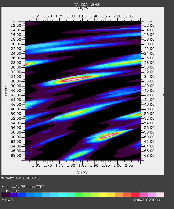
| Estimated Moho Depth: |
34.75 km |
| Estimated Crust Vp/Vs: |
1.82 |
| Assumed Crust Vp: |
6.53 km/s |
| Estimated Crust Vs: |
3.588 km/s |
| Estimated Crust Poisson's Ratio: |
0.28 |
|
| Radial Match: |
91.060555 % |
| Radial Bump: |
400 |
| Transverse Match: |
71.839455 % |
| Transverse Bump: |
400 |
| SOD ConfigId: |
393008 |
| Insert Time: |
2011-10-31 23:57:33.623 +0000 |
| GWidth: |
2.5 |
| Max Bumps: |
400 |
| Tol: |
0.001 |
|

Signal To Noise
| Channel | StoN | STA | LTA |
| TA:J30A: :BHZ:20110601T13:07:18.999995Z | 5.036547 | 3.451327E-7 | 6.852566E-8 |
| TA:J30A: :BHN:20110601T13:07:18.999995Z | 1.4806852 | 1.5289632E-7 | 1.0326052E-7 |
| TA:J30A: :BHE:20110601T13:07:18.999995Z | 1.2506592 | 1.3496383E-7 | 1.0791415E-7 |
| Arrivals |
| Ps | 4.5 SECOND |
| PpPs | 15 SECOND |
| PsPs/PpSs | 19 SECOND |


