You are here: Home > Network List > TA - USArray Transportable Network (new EarthScope stations) Stations List
> Station W32A Sentinel, OK, USA > Earthquake Result Viewer
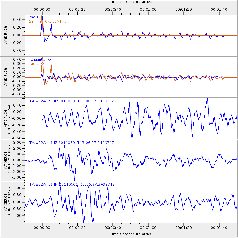
W32A Sentinel, OK, USA - Earthquake Result Viewer

| Earthquake location: |
Near Coast Of Central Chile |
| Earthquake latitude/longitude: |
-37.6/-73.7 |
| Earthquake time(UTC): |
2011/06/01 (152) 12:55:22 GMT |
| Earthquake Depth: |
21 km |
| Earthquake Magnitude: |
5.6 MB, 6.2 MS, 6.3 MW, 6.3 MW |
| Earthquake Catalog/Contributor: |
WHDF/NEIC |
|
| Network: |
TA USArray Transportable Network (new EarthScope stations) |
| Station: |
W32A Sentinel, OK, USA |
| Lat/Lon: |
35.12 N/99.25 W |
| Elevation: |
494 m |
|
| Distance: |
76.1 deg |
| Az: |
338.64 deg |
| Baz: |
159.328 deg |
| Ray Param: |
0.05118101 |
| Estimated Moho Depth: |
40.25 km |
| Estimated Crust Vp/Vs: |
1.82 |
| Assumed Crust Vp: |
6.315 km/s |
| Estimated Crust Vs: |
3.475 km/s |
| Estimated Crust Poisson's Ratio: |
0.28 |
|
| Radial Match: |
90.36767 % |
| Radial Bump: |
400 |
| Transverse Match: |
67.51165 % |
| Transverse Bump: |
400 |
| SOD ConfigId: |
393008 |
| Insert Time: |
2011-10-31 23:58:19.920 +0000 |
| GWidth: |
2.5 |
| Max Bumps: |
400 |
| Tol: |
0.001 |
|
Signal To Noise
| Channel | StoN | STA | LTA |
| TA:W32A: :BHZ:20110601T13:06:37.349971Z | 2.1398735 | 4.0213015E-7 | 1.8792238E-7 |
| TA:W32A: :BHN:20110601T13:06:37.349971Z | 1.110591 | 1.8180614E-7 | 1.6370214E-7 |
| TA:W32A: :BHE:20110601T13:06:37.349971Z | 1.2687547 | 1.9229563E-7 | 1.515625E-7 |
| Arrivals |
| Ps | 5.4 SECOND |
| PpPs | 17 SECOND |
| PsPs/PpSs | 23 SECOND |


