You are here: Home > Network List > TA - USArray Transportable Network (new EarthScope stations) Stations List
> Station 337A Centerville, TX, USA > Earthquake Result Viewer
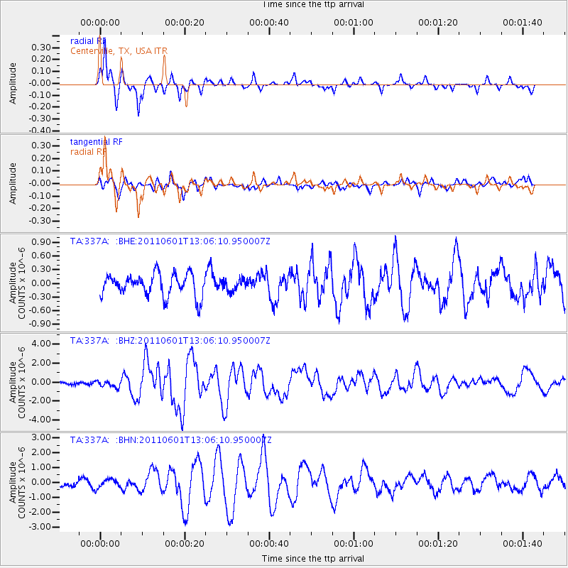
337A Centerville, TX, USA - Earthquake Result Viewer
*The percent match for this event was below the threshold and hence no stack was calculated.
| Earthquake location: |
Near Coast Of Central Chile |
| Earthquake latitude/longitude: |
-37.6/-73.7 |
| Earthquake time(UTC): |
2011/06/01 (152) 12:55:22 GMT |
| Earthquake Depth: |
21 km |
| Earthquake Magnitude: |
5.6 MB, 6.2 MS, 6.3 MW, 6.3 MW |
| Earthquake Catalog/Contributor: |
WHDF/NEIC |
|
| Network: |
TA USArray Transportable Network (new EarthScope stations) |
| Station: |
337A Centerville, TX, USA |
| Lat/Lon: |
31.32 N/95.89 W |
| Elevation: |
150 m |
|
| Distance: |
71.6 deg |
| Az: |
340.08 deg |
| Baz: |
161.562 deg |
| Ray Param: |
$rayparam |
*The percent match for this event was below the threshold and hence was not used in the summary stack. |
|
| Radial Match: |
92.90321 % |
| Radial Bump: |
290 |
| Transverse Match: |
69.337494 % |
| Transverse Bump: |
400 |
| SOD ConfigId: |
393008 |
| Insert Time: |
2011-11-01 00:00:34.771 +0000 |
| GWidth: |
2.5 |
| Max Bumps: |
400 |
| Tol: |
0.001 |
|
Signal To Noise
| Channel | StoN | STA | LTA |
| TA:337A: :BHZ:20110601T13:06:10.950007Z | 2.2238832 | 3.444798E-7 | 1.5490014E-7 |
| TA:337A: :BHN:20110601T13:06:10.950007Z | 0.97377604 | 2.6803497E-7 | 2.7525317E-7 |
| TA:337A: :BHE:20110601T13:06:10.950007Z | 0.52230895 | 1.2720423E-7 | 2.4354213E-7 |
| Arrivals |
| Ps | |
| PpPs | |
| PsPs/PpSs | |


