You are here: Home > Network List > TA - USArray Transportable Network (new EarthScope stations) Stations List
> Station 336A Riesel, TX, USA > Earthquake Result Viewer
336A Riesel, TX, USA - Earthquake Result Viewer
| Earthquake location: |
Near Coast Of Central Chile |
| Earthquake latitude/longitude: |
-37.6/-73.7 |
| Earthquake time(UTC): |
2011/06/01 (152) 12:55:22 GMT |
| Earthquake Depth: |
21 km |
| Earthquake Magnitude: |
5.6 MB, 6.2 MS, 6.3 MW, 6.3 MW |
| Earthquake Catalog/Contributor: |
WHDF/NEIC |
|
| Network: |
TA USArray Transportable Network (new EarthScope stations) |
| Station: |
336A Riesel, TX, USA |
| Lat/Lon: |
31.39 N/96.84 W |
| Elevation: |
140 m |
|
| Distance: |
71.9 deg |
| Az: |
339.287 deg |
| Baz: |
160.817 deg |
| Ray Param: |
0.053970642 |
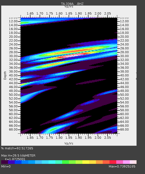
| Estimated Moho Depth: |
29.5 km |
| Estimated Crust Vp/Vs: |
1.87 |
| Assumed Crust Vp: |
6.347 km/s |
| Estimated Crust Vs: |
3.39 km/s |
| Estimated Crust Poisson's Ratio: |
0.30 |
|
| Radial Match: |
92.517265 % |
| Radial Bump: |
400 |
| Transverse Match: |
45.870056 % |
| Transverse Bump: |
400 |
| SOD ConfigId: |
393008 |
| Insert Time: |
2011-11-01 00:00:44.576 +0000 |
| GWidth: |
2.5 |
| Max Bumps: |
400 |
| Tol: |
0.001 |
|

Signal To Noise
| Channel | StoN | STA | LTA |
| TA:336A: :BHZ:20110601T13:06:12.924983Z | 3.7621481 | 3.638624E-7 | 9.671666E-8 |
| TA:336A: :BHN:20110601T13:06:12.924983Z | 1.2008957 | 2.6535994E-7 | 2.2096835E-7 |
| TA:336A: :BHE:20110601T13:06:12.924983Z | 0.82181364 | 4.936794E-7 | 6.007194E-7 |
| Arrivals |
| Ps | 4.2 SECOND |
| PpPs | 13 SECOND |
| PsPs/PpSs | 17 SECOND |


