You are here: Home > Network List > TA - USArray Transportable Network (new EarthScope stations) Stations List
> Station 238A Jacksonville, TX, USA > Earthquake Result Viewer
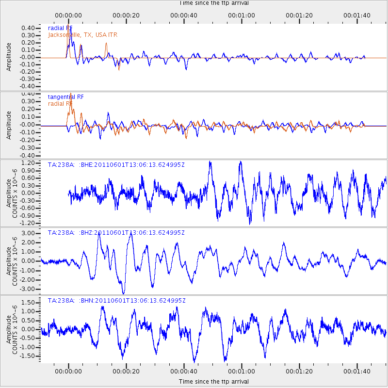
238A Jacksonville, TX, USA - Earthquake Result Viewer

| Earthquake location: |
Near Coast Of Central Chile |
| Earthquake latitude/longitude: |
-37.6/-73.7 |
| Earthquake time(UTC): |
2011/06/01 (152) 12:55:22 GMT |
| Earthquake Depth: |
21 km |
| Earthquake Magnitude: |
5.6 MB, 6.2 MS, 6.3 MW, 6.3 MW |
| Earthquake Catalog/Contributor: |
WHDF/NEIC |
|
| Network: |
TA USArray Transportable Network (new EarthScope stations) |
| Station: |
238A Jacksonville, TX, USA |
| Lat/Lon: |
32.00 N/95.12 W |
| Elevation: |
126 m |
|
| Distance: |
72.1 deg |
| Az: |
340.957 deg |
| Baz: |
162.235 deg |
| Ray Param: |
0.05389236 |
| Estimated Moho Depth: |
11.0 km |
| Estimated Crust Vp/Vs: |
1.60 |
| Assumed Crust Vp: |
6.245 km/s |
| Estimated Crust Vs: |
3.903 km/s |
| Estimated Crust Poisson's Ratio: |
0.18 |
|
| Radial Match: |
93.64297 % |
| Radial Bump: |
400 |
| Transverse Match: |
87.71373 % |
| Transverse Bump: |
400 |
| SOD ConfigId: |
393008 |
| Insert Time: |
2011-11-01 00:01:09.804 +0000 |
| GWidth: |
2.5 |
| Max Bumps: |
400 |
| Tol: |
0.001 |
|
Signal To Noise
| Channel | StoN | STA | LTA |
| TA:238A: :BHZ:20110601T13:06:13.624995Z | 2.7035491 | 3.1649108E-7 | 1.1706503E-7 |
| TA:238A: :BHN:20110601T13:06:13.624995Z | 0.7854161 | 1.4194283E-7 | 1.807231E-7 |
| TA:238A: :BHE:20110601T13:06:13.624995Z | 0.9921992 | 2.135732E-7 | 2.1525234E-7 |
| Arrivals |
| Ps | 1.1 SECOND |
| PpPs | 4.4 SECOND |
| PsPs/PpSs | 5.5 SECOND |


