You are here: Home > Network List > TA - USArray Transportable Network (new EarthScope stations) Stations List
> Station S35A Otter Creek Ranch, Eureka, KS, USA > Earthquake Result Viewer
S35A Otter Creek Ranch, Eureka, KS, USA - Earthquake Result Viewer
| Earthquake location: |
Near Coast Of Central Chile |
| Earthquake latitude/longitude: |
-37.6/-73.7 |
| Earthquake time(UTC): |
2011/06/01 (152) 12:55:22 GMT |
| Earthquake Depth: |
21 km |
| Earthquake Magnitude: |
5.6 MB, 6.2 MS, 6.3 MW, 6.3 MW |
| Earthquake Catalog/Contributor: |
WHDF/NEIC |
|
| Network: |
TA USArray Transportable Network (new EarthScope stations) |
| Station: |
S35A Otter Creek Ranch, Eureka, KS, USA |
| Lat/Lon: |
37.68 N/96.32 W |
| Elevation: |
334 m |
|
| Distance: |
77.7 deg |
| Az: |
341.798 deg |
| Baz: |
161.772 deg |
| Ray Param: |
0.050089423 |
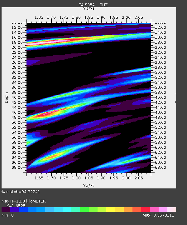
| Estimated Moho Depth: |
18.0 km |
| Estimated Crust Vp/Vs: |
1.65 |
| Assumed Crust Vp: |
6.483 km/s |
| Estimated Crust Vs: |
3.923 km/s |
| Estimated Crust Poisson's Ratio: |
0.21 |
|
| Radial Match: |
94.32241 % |
| Radial Bump: |
346 |
| Transverse Match: |
83.5841 % |
| Transverse Bump: |
400 |
| SOD ConfigId: |
393008 |
| Insert Time: |
2011-11-01 00:02:03.430 +0000 |
| GWidth: |
2.5 |
| Max Bumps: |
400 |
| Tol: |
0.001 |
|
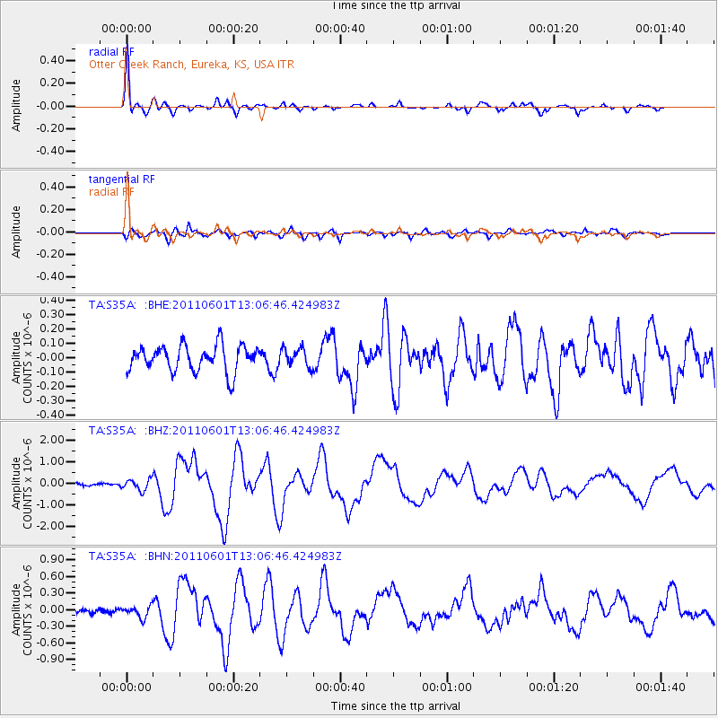
Signal To Noise
| Channel | StoN | STA | LTA |
| TA:S35A: :BHZ:20110601T13:06:46.424983Z | 2.8101227 | 2.58365E-7 | 9.194082E-8 |
| TA:S35A: :BHN:20110601T13:06:46.424983Z | 1.9917271 | 1.0476744E-7 | 5.2601298E-8 |
| TA:S35A: :BHE:20110601T13:06:46.424983Z | 0.7110495 | 6.420142E-8 | 9.029107E-8 |
| Arrivals |
| Ps | 1.9 SECOND |
| PpPs | 7.1 SECOND |
| PsPs/PpSs | 9.0 SECOND |


