You are here: Home > Network List > TA - USArray Transportable Network (new EarthScope stations) Stations List
> Station W35A Tecumseh, OK, USA > Earthquake Result Viewer
W35A Tecumseh, OK, USA - Earthquake Result Viewer
| Earthquake location: |
Near Coast Of Central Chile |
| Earthquake latitude/longitude: |
-37.6/-73.7 |
| Earthquake time(UTC): |
2011/06/01 (152) 12:55:22 GMT |
| Earthquake Depth: |
21 km |
| Earthquake Magnitude: |
5.6 MB, 6.2 MS, 6.3 MW, 6.3 MW |
| Earthquake Catalog/Contributor: |
WHDF/NEIC |
|
| Network: |
TA USArray Transportable Network (new EarthScope stations) |
| Station: |
W35A Tecumseh, OK, USA |
| Lat/Lon: |
35.15 N/96.87 W |
| Elevation: |
322 m |
|
| Distance: |
75.5 deg |
| Az: |
340.536 deg |
| Baz: |
161.151 deg |
| Ray Param: |
0.051606644 |
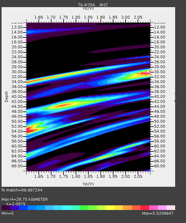
| Estimated Moho Depth: |
29.75 km |
| Estimated Crust Vp/Vs: |
2.10 |
| Assumed Crust Vp: |
6.426 km/s |
| Estimated Crust Vs: |
3.064 km/s |
| Estimated Crust Poisson's Ratio: |
0.35 |
|
| Radial Match: |
86.667244 % |
| Radial Bump: |
400 |
| Transverse Match: |
74.76815 % |
| Transverse Bump: |
400 |
| SOD ConfigId: |
393008 |
| Insert Time: |
2011-11-01 00:02:16.407 +0000 |
| GWidth: |
2.5 |
| Max Bumps: |
400 |
| Tol: |
0.001 |
|

Signal To Noise
| Channel | StoN | STA | LTA |
| TA:W35A: :BHZ:20110601T13:06:33.749995Z | 3.002276 | 2.7730047E-7 | 9.2363415E-8 |
| TA:W35A: :BHN:20110601T13:06:33.749995Z | 0.9131498 | 1.2401979E-7 | 1.358154E-7 |
| TA:W35A: :BHE:20110601T13:06:33.749995Z | 0.422341 | 7.39177E-8 | 1.75019E-7 |
| Arrivals |
| Ps | 5.2 SECOND |
| PpPs | 14 SECOND |
| PsPs/PpSs | 19 SECOND |


