You are here: Home > Network List > TA - USArray Transportable Network (new EarthScope stations) Stations List
> Station X37A Clayton, OK, USA > Earthquake Result Viewer
X37A Clayton, OK, USA - Earthquake Result Viewer
| Earthquake location: |
Near Coast Of Central Chile |
| Earthquake latitude/longitude: |
-37.6/-73.7 |
| Earthquake time(UTC): |
2011/06/01 (152) 12:55:22 GMT |
| Earthquake Depth: |
21 km |
| Earthquake Magnitude: |
5.6 MB, 6.2 MS, 6.3 MW, 6.3 MW |
| Earthquake Catalog/Contributor: |
WHDF/NEIC |
|
| Network: |
TA USArray Transportable Network (new EarthScope stations) |
| Station: |
X37A Clayton, OK, USA |
| Lat/Lon: |
34.59 N/95.37 W |
| Elevation: |
207 m |
|
| Distance: |
74.6 deg |
| Az: |
341.569 deg |
| Baz: |
162.274 deg |
| Ray Param: |
0.052218337 |
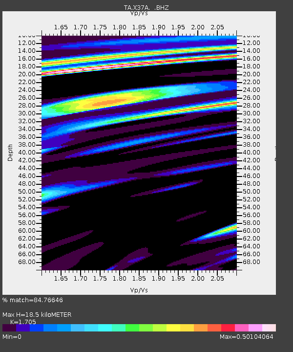
| Estimated Moho Depth: |
18.5 km |
| Estimated Crust Vp/Vs: |
1.71 |
| Assumed Crust Vp: |
6.498 km/s |
| Estimated Crust Vs: |
3.811 km/s |
| Estimated Crust Poisson's Ratio: |
0.24 |
|
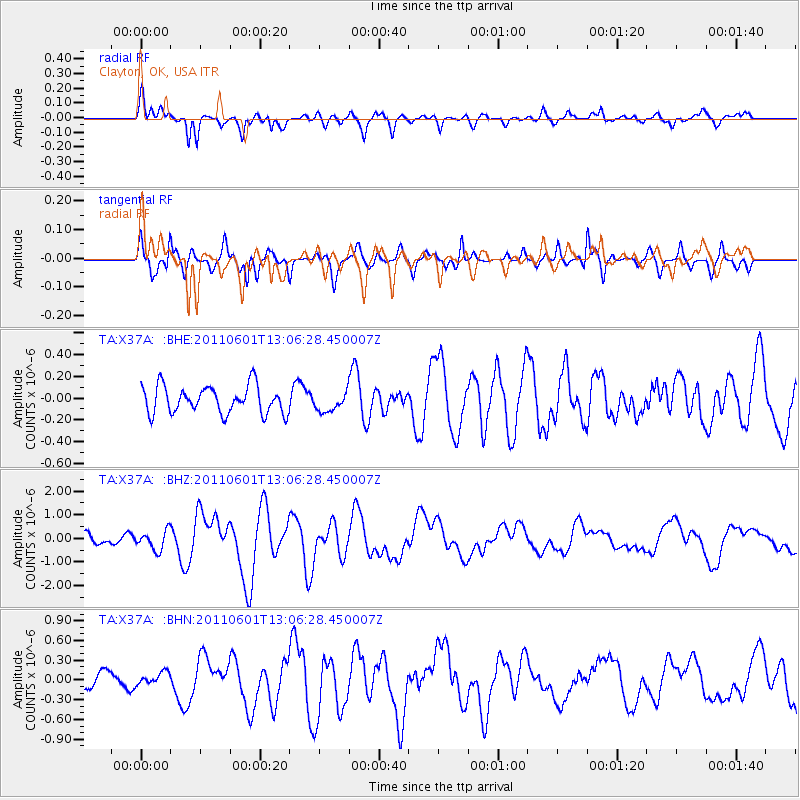
| Radial Match: |
84.76646 % |
| Radial Bump: |
400 |
| Transverse Match: |
79.04362 % |
| Transverse Bump: |
353 |
| SOD ConfigId: |
393008 |
| Insert Time: |
2011-11-01 00:02:22.502 +0000 |
| GWidth: |
2.5 |
| Max Bumps: |
400 |
| Tol: |
0.001 |
|
Signal To Noise
| Channel | StoN | STA | LTA |
| TA:X37A: :BHZ:20110601T13:06:28.450007Z | 2.8246105 | 4.036363E-7 | 1.4289981E-7 |
| TA:X37A: :BHN:20110601T13:06:28.450007Z | 0.5498274 | 9.2041695E-8 | 1.6740107E-7 |
| TA:X37A: :BHE:20110601T13:06:28.450007Z | 0.7073752 | 8.887319E-8 | 1.2563798E-7 |
| Arrivals |
| Ps | 2.1 SECOND |
| PpPs | 7.4 SECOND |
| PsPs/PpSs | 9.5 SECOND |


