You are here: Home > Network List > TA - USArray Transportable Network (new EarthScope stations) Stations List
> Station J33A Davis, SD, USA > Earthquake Result Viewer
J33A Davis, SD, USA - Earthquake Result Viewer

| Earthquake location: |
Near Coast Of Central Chile |
| Earthquake latitude/longitude: |
-37.6/-73.7 |
| Earthquake time(UTC): |
2011/06/01 (152) 12:55:22 GMT |
| Earthquake Depth: |
21 km |
| Earthquake Magnitude: |
5.6 MB, 6.2 MS, 6.3 MW, 6.3 MW |
| Earthquake Catalog/Contributor: |
WHDF/NEIC |
|
| Network: |
TA USArray Transportable Network (new EarthScope stations) |
| Station: |
J33A Davis, SD, USA |
| Lat/Lon: |
43.32 N/96.97 W |
| Elevation: |
400 m |
|
| Distance: |
83.3 deg |
| Az: |
343.117 deg |
| Baz: |
161.57 deg |
| Ray Param: |
0.04630231 |
| Estimated Moho Depth: |
48.0 km |
| Estimated Crust Vp/Vs: |
1.64 |
| Assumed Crust Vp: |
6.498 km/s |
| Estimated Crust Vs: |
3.956 km/s |
| Estimated Crust Poisson's Ratio: |
0.21 |
|
| Radial Match: |
91.091156 % |
| Radial Bump: |
400 |
| Transverse Match: |
81.594215 % |
| Transverse Bump: |
400 |
| SOD ConfigId: |
393008 |
| Insert Time: |
2011-11-01 00:06:03.074 +0000 |
| GWidth: |
2.5 |
| Max Bumps: |
400 |
| Tol: |
0.001 |
|
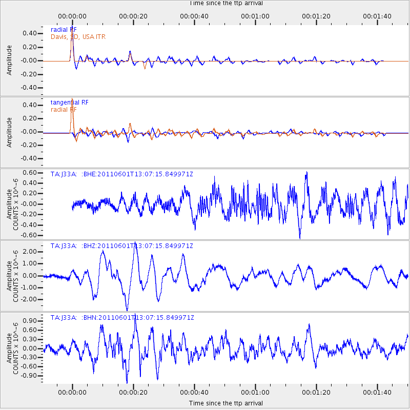
Signal To Noise
| Channel | StoN | STA | LTA |
| TA:J33A: :BHZ:20110601T13:07:15.849971Z | 3.514742 | 3.4205024E-7 | 9.731873E-8 |
| TA:J33A: :BHN:20110601T13:07:15.849971Z | 2.0025933 | 1.8701556E-7 | 9.338669E-8 |
| TA:J33A: :BHE:20110601T13:07:15.849971Z | 1.02883 | 8.9984766E-8 | 8.74632E-8 |
| Arrivals |
| Ps | 4.9 SECOND |
| PpPs | 19 SECOND |
| PsPs/PpSs | 24 SECOND |


