You are here: Home > Network List > TA - USArray Transportable Network (new EarthScope stations) Stations List
> Station W56A Indian Trail, NC, USA > Earthquake Result Viewer
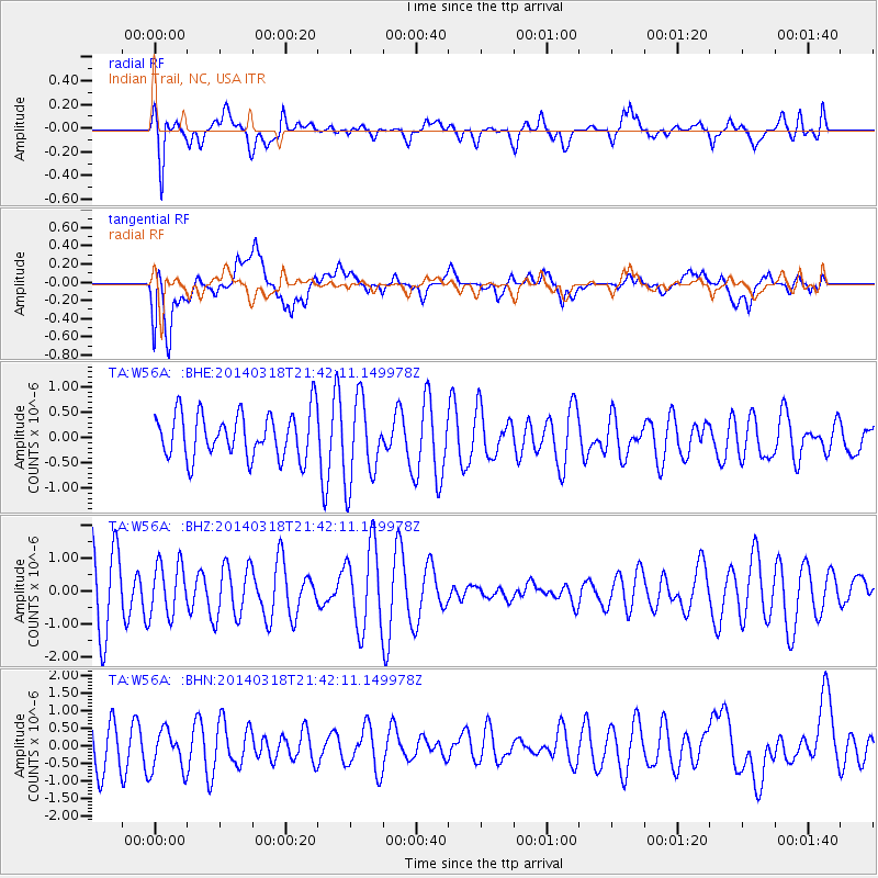
W56A Indian Trail, NC, USA - Earthquake Result Viewer
*The percent match for this event was below the threshold and hence no stack was calculated.
| Earthquake location: |
Near Coast Of Northern Chile |
| Earthquake latitude/longitude: |
-20.0/-70.9 |
| Earthquake time(UTC): |
2014/03/18 (077) 21:33:05 GMT |
| Earthquake Depth: |
6.3 km |
| Earthquake Magnitude: |
5.1 mb |
| Earthquake Catalog/Contributor: |
ISC/ISC |
|
| Network: |
TA USArray Transportable Network (new EarthScope stations) |
| Station: |
W56A Indian Trail, NC, USA |
| Lat/Lon: |
35.13 N/80.58 W |
| Elevation: |
177 m |
|
| Distance: |
55.6 deg |
| Az: |
350.417 deg |
| Baz: |
168.988 deg |
| Ray Param: |
$rayparam |
*The percent match for this event was below the threshold and hence was not used in the summary stack. |
|
| Radial Match: |
74.07372 % |
| Radial Bump: |
400 |
| Transverse Match: |
48.593575 % |
| Transverse Bump: |
400 |
| SOD ConfigId: |
3390531 |
| Insert Time: |
2019-04-10 18:19:19.352 +0000 |
| GWidth: |
2.5 |
| Max Bumps: |
400 |
| Tol: |
0.001 |
|
Signal To Noise
| Channel | StoN | STA | LTA |
| TA:W56A: :BHZ:20140318T21:42:11.149978Z | 0.7113745 | 8.0086863E-7 | 1.1258045E-6 |
| TA:W56A: :BHN:20140318T21:42:11.149978Z | 0.5659033 | 6.03282E-7 | 1.0660514E-6 |
| TA:W56A: :BHE:20140318T21:42:11.149978Z | 1.8515028 | 8.2971974E-7 | 4.4813314E-7 |
| Arrivals |
| Ps | |
| PpPs | |
| PsPs/PpSs | |


